Ezine night lights from space
Night Light of Ezine (Canakkale) from space (Turkey) Src. Average luminocity for 10x10km area is 13.199% and for 50x50km: 3.2774%.
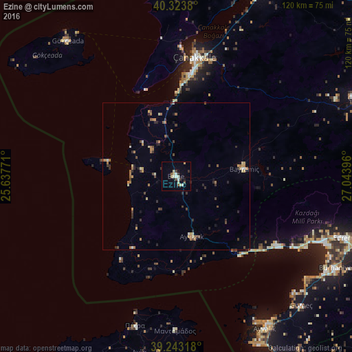
Analysis of Ezine night lights 2016
Square area 10x10 km:
 1.19%
1.19%90-99
2.72%80-89
3.74%70-79
0.51%60-69
0%50-59
1.36%40-49
2.04%30-39
1.36%20-29
1.36%10-19
1.19%0-9
84.52%Square area 50x50 km:
0.07%90-99
0.34%80-89
0.48%70-79
0.44%60-69
0.76%50-59
0.29%40-49
0.6%30-39
0.61%20-29
0.73%10-19
0.41%0-9
95.27%Clear (daylight) street map image can be seen on geolist.org.
Map coordinates:
40° 19' 25.7" North, 25° 38' 15.8" East
39° 47' 8.2" North, 26° 20' 27" East
39° 14' 35.4" North, 27° 2' 38.3" East
Some cities around Ezine sort by population:
• Çanakkale
41.6 km =25.8 mi,  8°
8°
• Ayvalık
60 km =37.3 mi,  149°
149°
• Edremit
62.2 km =38.6 mi,  109°
109°
• Burhaniye
62.7 km =39 mi,  120°
120°
• Altınoluk
40.9 km =25.4 mi, 124°
• Gökçeada
59.1 km =36.7 mi,  321°
321°
• Ayvacık
21.2 km =13.2 mi,  165°
165°
• Eceabat
44.3 km =27.5 mi,  1°
1°
315061 (p: 15,677)
Sources (retrieved 2019-11-25):
» Earth at Night: Flat Maps 2012, 2016