Aladağ night lights from space
Night Light of Aladağ (Adana) from space (Turkey) Src. Average luminocity for 10x10km area is 6.039% and for 50x50km: 1.0567%.
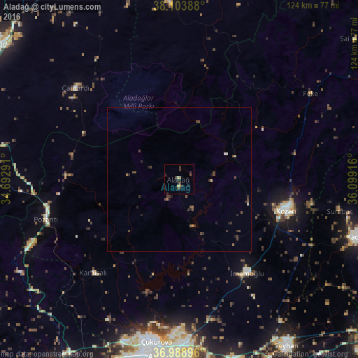
Analysis of Aladağ night lights 2016
Square area 10x10 km:
100  0%
0%
90-99 0%
80-89 1.14%
70-79 0.81%
60-69 0.65%
50-59 0.32%
40-49 1.62%
30-39 4.55%
20-29 1.3%
10-19 1.62%
0-9 87.99%
0%90-99
0%80-89
1.14%70-79
0.81%60-69
0.65%50-59
0.32%40-49
1.62%30-39
4.55%20-29
1.3%10-19
1.62%0-9
87.99%Square area 50x50 km:
100 0%
90-99 0.11%
80-89 0.07%
70-79 0.05%
60-69 0.13%
50-59 0.24%
40-49 0.49%
30-39 0.48%
20-29 0.31%
10-19 0.25%
0-9 97.88%
0%90-99
0.11%80-89
0.07%70-79
0.05%60-69
0.13%50-59
0.24%40-49
0.49%30-39
0.48%20-29
0.31%10-19
0.25%0-9
97.88%Clear (daylight) street map image can be seen on geolist.org.
Map coordinates:
38° 6' 14" North, 34° 41' 34.5" East
37° 32' 54.6" North, 35° 23' 45.7" East
36° 59' 20.3" North, 36° 5' 57" East
Some cities around Aladağ sort by population:
• Adana
61.1 km =38 mi,  185°
185°
• Ceyhan
69.2 km =43 mi,  147°
147°
• Kozan
38.4 km =23.9 mi,  105°
105°
• Kadirli
64.8 km =40.3 mi, 107°
• İmamoğlu
39.1 km =24.3 mi,  143°
143°
• Yahyalı
61.7 km =38.3 mi,  356°
356°
• Pozantı
48.2 km =30 mi,  253°
253°
• Karaisalı
44 km =27.3 mi,  222°
222°
308998 (p: 7,613)
Sources (retrieved 2019-11-25):
» Earth at Night: Flat Maps 2012, 2016