Pozantı night lights from space
Night Light of Pozantı (Adana) from space (Turkey) Src. Average luminocity for 10x10km area is 17.8247% and for 50x50km: 4.2448%.
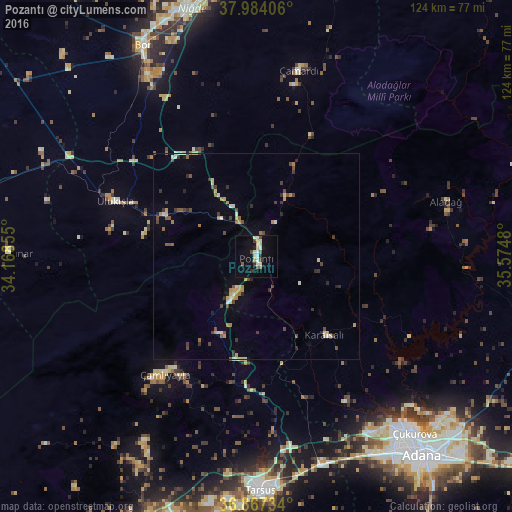
Analysis of Pozantı night lights 2016
Square area 10x10 km:
100  0.65%
0.65%
90-99 5.52%
80-89 2.76%
70-79 1.46%
60-69 0.16%
50-59 1.79%
40-49 2.27%
30-39 1.62%
20-29 1.95%
10-19 12.99%
0-9 68.83%
0.65%90-99
5.52%80-89
2.76%70-79
1.46%60-69
0.16%50-59
1.79%40-49
2.27%30-39
1.62%20-29
1.95%10-19
12.99%0-9
68.83%Square area 50x50 km:
100 0.06%
90-99 0.76%
80-89 0.43%
70-79 0.78%
60-69 0.3%
50-59 0.54%
40-49 0.88%
30-39 0.76%
20-29 0.6%
10-19 0.98%
0-9 93.91%
0.06%90-99
0.76%80-89
0.43%70-79
0.78%60-69
0.3%50-59
0.54%40-49
0.88%30-39
0.76%20-29
0.6%10-19
0.98%0-9
93.91%Clear (daylight) street map image can be seen on geolist.org.
Map coordinates:
37° 59' 2.6" North, 34° 10' 6.8" East
37° 25' 40" North, 34° 52' 18" East
36° 52' 2.4" North, 35° 34' 29.3" East
Some cities around Pozantı sort by population:
• Adana
62.3 km =38.7 mi,  139°
139°
• Mersin
71.5 km =44.4 mi,  196°
196°
• Tarsus
56.8 km =35.3 mi,  178°
178°
• Niğde
62.2 km =38.6 mi,  344°
344°
• Bor
58.4 km =36.3 mi,  331°
331°
• İmamoğlu
71.8 km =44.6 mi,  104°
104°
• Aladağ
48.2 km =30 mi,  73°
73°
• Karaisalı
25.2 km =15.7 mi, 138°
302482 (p: 10,517)
Sources (retrieved 2019-11-25):
» Earth at Night: Flat Maps 2012, 2016