Pong Nam Ron night lights from space
Night Light of Pong Nam Ron (Chanthaburi) from space (Thailand) Src. Average luminocity for 10x10km area is 2.6732% and for 50x50km: 2.2262%.
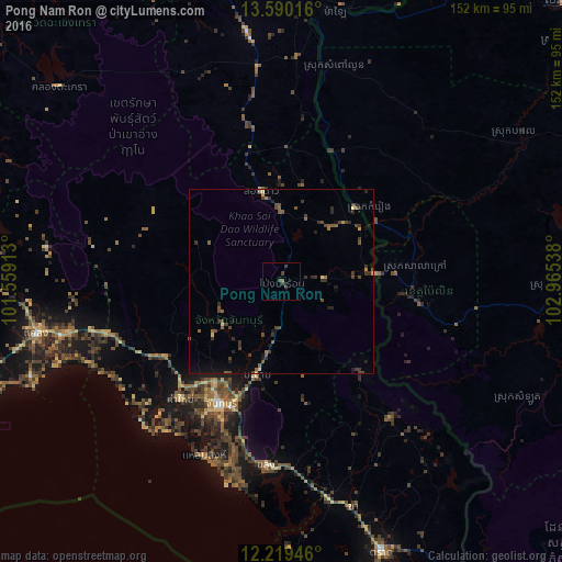
Analysis of Pong Nam Ron night lights 2016
Square area 10x10 km:
 0%
0%90-99
0%80-89
0%70-79
0%60-69
0%50-59
0.87%40-49
2.16%30-39
2.16%20-29
0%10-19
0.87%0-9
93.94%Square area 50x50 km:
0%90-99
0%80-89
0.2%70-79
0.14%60-69
0.28%50-59
0.58%40-49
0.88%30-39
1.01%20-29
0.66%10-19
0.74%0-9
95.51%Clear (daylight) street map image can be seen on geolist.org.
Map coordinates:
13° 35' 24.6" North, 101° 33' 32.9" East
12° 54' 20.7" North, 102° 15' 44.1" East
12° 13' 10.1" North, 102° 57' 55.4" East
Some cities around Pong Nam Ron sort by population:
• Chanthaburi
37.1 km =23.1 mi,  207°
207°
• Klaeng
68 km =42.3 mi,  258°
258°
• Tha Mai
42.2 km =26.2 mi,  221°
221°
• Pailin, KH
38.1 km =23.7 mi,  99°
99°
• Wang Nam Yen
67 km =41.6 mi,  352°
352°
• Laem Sing
51.4 km =31.9 mi,  203°
203°
• Bo Rai
47.5 km =29.5 mi,  141°
141°
• Khlung
50.4 km =31.3 mi,  185°
185°
1607306 (p: 8,878)
Sources (retrieved 2019-11-25):
» Earth at Night: Flat Maps 2012, 2016