Nuea Khlong night lights from space
Night Light of Nuea Khlong (Krabi) from space (Thailand) Src. Average luminocity for 10x10km area is 28.4112% and for 50x50km: 6.2694%.
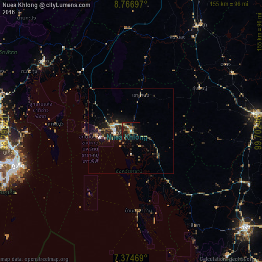
Analysis of Nuea Khlong night lights 2016
Square area 10x10 km:
 1.45%
1.45%90-99
1.03%80-89
3.93%70-79
4.96%60-69
4.75%50-59
7.02%40-49
3.31%30-39
6.61%20-29
12.4%10-19
25.83%0-9
28.72%Square area 50x50 km:
0.29%90-99
0.58%80-89
0.67%70-79
0.88%60-69
0.64%50-59
1.13%40-49
1.26%30-39
1.43%20-29
2.69%10-19
5.15%0-9
85.28%Clear (daylight) street map image can be seen on geolist.org.
Map coordinates:
8° 46' 1.1" North, 98° 17' 46.4" East
8° 4' 17.1" North, 98° 59' 57.6" East
7° 22' 28.9" North, 99° 42' 8.9" East
Some cities around Nuea Khlong sort by population:
• Krabi
9.8 km =6.1 mi,  270°
270°
• Ao Luek
45.8 km =28.5 mi,  318°
318°
• Ban Ao Nang
21 km =13 mi,  262°
262°
• Saladan
51.1 km =31.8 mi,  175°
175°
• Tham Phannara
58.3 km =36.2 mi,  48°
48°
• Chai Buri
44.3 km =27.5 mi,  11°
11°
• Ko Lanta
60.6 km =37.7 mi,  170°
170°
• Ban Phru Nai
46.9 km =29.1 mi,  253°
253°
1155525 (p: 12,217)
Sources (retrieved 2019-11-25):
» Earth at Night: Flat Maps 2012, 2016