Ko Lanta night lights from space
Night Light of Ko Lanta (Krabi) from space (Thailand) Src. Average luminocity for 10x10km area is 1.2965% and for 50x50km: 0.9113%.
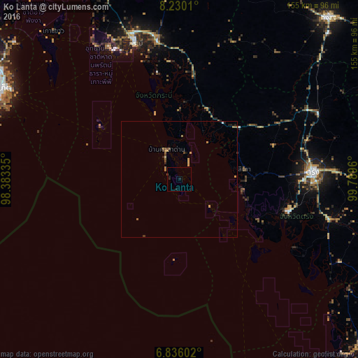
Analysis of Ko Lanta night lights 2016
Square area 10x10 km:
 0%
0%90-99
0%80-89
0%70-79
0%60-69
0%50-59
0.22%40-49
0.22%30-39
0%20-29
2.6%10-19
0.87%0-9
96.1%Square area 50x50 km:
0.01%90-99
0.03%80-89
0.05%70-79
0.37%60-69
0.19%50-59
0.15%40-49
0.18%30-39
0.08%20-29
0.27%10-19
0.16%0-9
98.52%Clear (daylight) street map image can be seen on geolist.org.
Map coordinates:
8° 13' 48.4" North, 98° 23' 0.1" East
7° 32' 1" North, 99° 5' 11.3" East
6° 50' 9.7" North, 99° 47' 22.6" East
Some cities around Ko Lanta sort by population:
• Trang
57.9 km =36 mi,  87°
87°
• Krabi
63 km =39.1 mi,  342°
342°
• Huai Yot
66.8 km =41.5 mi,  64°
64°
• Kantang
49.4 km =30.7 mi,  106°
106°
• Nuea Khlong
60.6 km =37.7 mi,  350°
350°
• Ban Ao Nang
64.6 km =40.1 mi,  331°
331°
• Saladan
10.4 km =6.5 mi, 328°
• Ban Phru Nai
72 km =44.7 mi,  310°
310°
1152670 (p: 6,090)
Sources (retrieved 2019-11-25):
» Earth at Night: Flat Maps 2012, 2016