Ao Luek night lights from space
Night Light of Ao Luek (Krabi) from space (Thailand) Src. Average luminocity for 10x10km area is 4.0537% and for 50x50km: 2.2084%.
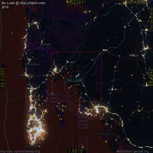
Analysis of Ao Luek night lights 2016
Square area 10x10 km:
 0.83%
0.83%90-99
0.83%80-89
0%70-79
0%60-69
0.83%50-59
1.45%40-49
0.21%30-39
0%20-29
1.65%10-19
0%0-9
94.21%Square area 50x50 km:
0.11%90-99
0.19%80-89
0.16%70-79
0.28%60-69
0.24%50-59
0.5%40-49
0.44%30-39
0.64%20-29
0.77%10-19
0.85%0-9
95.83%Clear (daylight) street map image can be seen on geolist.org.
Map coordinates:
9° 4' 22.8" North, 98° 1' 5" East
8° 22' 40.9" North, 98° 43' 16.2" East
7° 40' 54.5" North, 99° 25' 27.5" East
Some cities around Ao Luek sort by population:
• Ban Ratsada
62.8 km =39 mi,  213°
213°
• Krabi
39.8 km =24.7 mi,  148°
148°
• Nuea Khlong
45.8 km =28.5 mi,  138°
138°
• Ban Ko Kaeo
60.8 km =37.8 mi,  216°
216°
• Phang Nga
22.6 km =14 mi,  291°
291°
• Ban Ao Nang
38.2 km =23.7 mi,  165°
165°
• Chai Buri
40.2 km =25 mi,  76°
76°
• Ban Phru Nai
49.3 km =30.6 mi,  197°
197°
1158412 (p: 9,628)
Sources (retrieved 2019-11-25):
» Earth at Night: Flat Maps 2012, 2016