Khon Buri night lights from space
Night Light of Khon Buri (Nakhon Ratchasima) from space (Thailand) Src. Average luminocity for 10x10km area is 8.7554% and for 50x50km: 3.0239%.
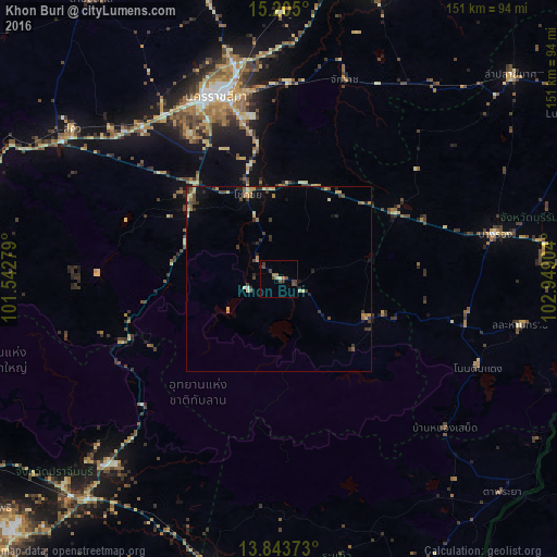
Analysis of Khon Buri night lights 2016
Square area 10x10 km:
 0%
0%90-99
0.22%80-89
1.52%70-79
0.22%60-69
2.38%50-59
0.87%40-49
4.76%30-39
3.03%20-29
0.43%10-19
0%0-9
86.58%Square area 50x50 km:
0.02%90-99
0.06%80-89
0.72%70-79
0.46%60-69
0.52%50-59
0.39%40-49
0.68%30-39
0.93%20-29
0.61%10-19
0.72%0-9
94.9%Clear (daylight) street map image can be seen on geolist.org.
Map coordinates:
15° 12' 18" North, 101° 32' 34" East
14° 31' 31.5" North, 102° 14' 45.3" East
13° 50' 37.4" North, 102° 56' 56.5" East
Some cities around Khon Buri sort by population:
• Nakhon Ratchasima
51.9 km =32.2 mi,  342°
342°
• Amphoe Sikhiu
71.2 km =44.2 mi,  305°
305°
• Chok Chai
24.2 km =15 mi, 338°
• Nang Rong
60 km =37.3 mi,  77°
77°
• Ban Huai Thalaeng
66.9 km =41.6 mi,  40°
40°
• Sung Noen
61.8 km =38.4 mi, 312°
• Soeng Sang
25.6 km =15.9 mi,  115°
115°
• Nong Ki
36.2 km =22.5 mi,  60°
60°
1609795 (p: 18,596)
Sources (retrieved 2019-11-25):
» Earth at Night: Flat Maps 2012, 2016