Bang Yai night lights from space
Night Light of Bang Yai (Nonthaburi) from space (Thailand) Src. Average luminocity for 10x10km area is 79.9256% and for 50x50km: 74.4876%.
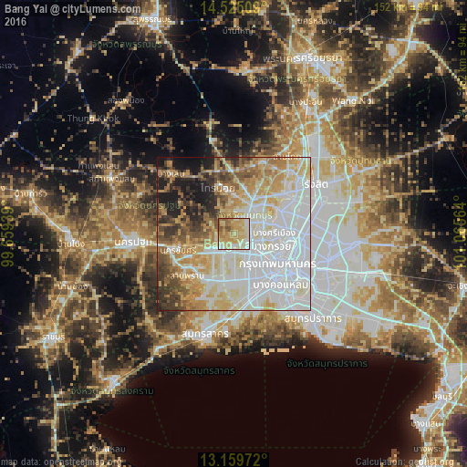
Analysis of Bang Yai night lights 2016
Square area 10x10 km:
 8.88%
8.88%90-99
15.08%80-89
31.61%70-79
23.76%60-69
10.33%50-59
7.44%40-49
2.89%30-39
0%20-29
0%10-19
0%0-9
0%Square area 50x50 km:
28.51%90-99
15.39%80-89
10.96%70-79
10.19%60-69
7.51%50-59
5.82%40-49
5.23%30-39
5.22%20-29
4.33%10-19
6.21%0-9
0.62%Clear (daylight) street map image can be seen on geolist.org.
Map coordinates:
14° 31' 30.3" North, 99° 39' 33.8" East
13° 50' 36.3" North, 100° 21' 45" East
13° 9' 35" North, 101° 3' 56.3" East
Some cities around Bang Yai sort by population:
• Bangkok
18 km =11.2 mi,  123°
123°
• Mueang Nonthaburi
16.6 km =10.3 mi,  83°
83°
• Pak Kret
16.6 km =10.3 mi,  62°
62°
• Phra Pradaeng
27.6 km =17.1 mi,  138°
138°
• Krathum Baen
23.9 km =14.9 mi,  207°
207°
• Sam Phran
20.5 km =12.7 mi,  230°
230°
• Ban Bang Kadi Pathum Thani
26.6 km =16.5 mi,  49°
49°
• Pathum Thani
26.2 km =16.3 mi,  43°
43°
1619198 (p: 14,012)
Sources (retrieved 2019-11-25):
» Earth at Night: Flat Maps 2012, 2016