Tacuba night lights from space
Night Light of Tacuba (Ahuachapán) from space (El Salvador) Src. Average luminocity for 10x10km area is 1.5537% and for 50x50km: 2.8284%.
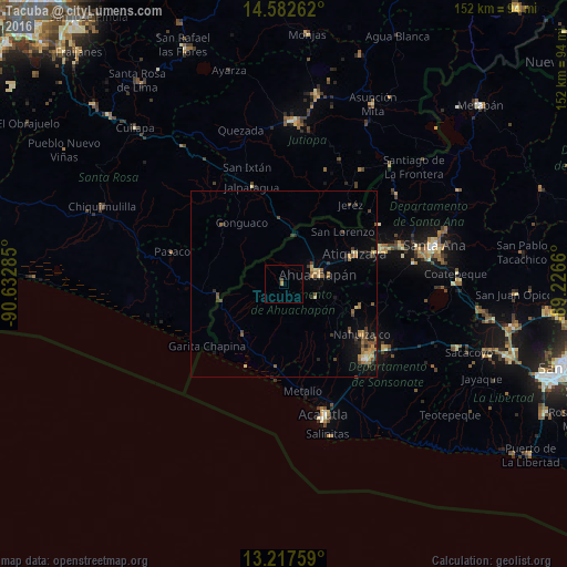
Analysis of Tacuba night lights 2016
Square area 10x10 km:
 0%
0%90-99
0%80-89
0%70-79
0.83%60-69
0%50-59
0.83%40-49
0%30-39
0%20-29
0%10-19
0%0-9
98.35%Square area 50x50 km:
0.04%90-99
0.12%80-89
0.46%70-79
0.35%60-69
0.72%50-59
0.46%40-49
0.74%30-39
0.54%20-29
0.6%10-19
0.96%0-9
95.01%Clear (daylight) street map image can be seen on geolist.org.
Map coordinates:
14° 34' 57.4" North, 90° 37' 58.3" West
13° 54' 4" North, 89° 55' 47" West
13° 13' 3.3" North, 89° 13' 35.8" West
Some cities around Tacuba sort by population:
• Ahuachapán
9.4 km =5.8 mi,  76°
76°
• Chalchuapa
28.5 km =17.7 mi,  70°
70°
• Jalpatagua, GT
28.1 km =17.5 mi,  342°
342°
• Juayúa
21 km =13 mi,  108°
108°
• Atiquizaya
20.9 km =13 mi, 66°
• Moyuta, GT
22.4 km =13.9 mi,  313°
313°
• Concepción de Ataco
9.4 km =5.8 mi, 111°
• Nahuizalco
25 km =15.5 mi,  123°
123°
3583065 (p: 5,055)
Sources (retrieved 2019-11-25):
» Earth at Night: Flat Maps 2012, 2016