Atiquizaya night lights from space
Night Light of Atiquizaya (Ahuachapán) from space (El Salvador) Src. Average luminocity for 10x10km area is 8.9394% and for 50x50km: 4.9437%.
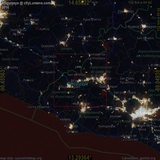
Analysis of Atiquizaya night lights 2016
Square area 10x10 km:
 0%
0%90-99
0.87%80-89
1.73%70-79
1.73%60-69
0.65%50-59
1.08%40-49
0.87%30-39
1.3%20-29
2.81%10-19
1.95%0-9
87.01%Square area 50x50 km:
0.1%90-99
0.24%80-89
0.86%70-79
0.75%60-69
0.86%50-59
0.87%40-49
1.02%30-39
1.03%20-29
0.76%10-19
3.77%0-9
89.74%Clear (daylight) street map image can be seen on geolist.org.
Map coordinates:
14° 39' 29.6" North, 90° 27' 20.3" West
13° 58' 37" North, 89° 45' 9" West
13° 17' 37.1" North, 89° 2' 57.8" West
Some cities around Atiquizaya sort by population:
• Santa Ana
20.9 km =13 mi,  84°
84°
• Ahuachapán
11.7 km =7.3 mi,  238°
238°
• Chalchuapa
7.8 km =4.8 mi, 82°
• Atescatempa, GT
22 km =13.7 mi,  2°
2°
• Juayúa
15.1 km =9.4 mi,  177°
177°
• Concepción de Ataco
15.8 km =9.8 mi,  221°
221°
• Candelaria de La Frontera
19.1 km =11.9 mi,  35°
35°
• Tacuba
20.9 km =13 mi,  246°
246°
3587317 (p: 9,476)
Sources (retrieved 2019-11-25):
» Earth at Night: Flat Maps 2012, 2016