Santo Tomás night lights from space
Night Light of Santo Tomás (San Salvador) from space (El Salvador) Src. Average luminocity for 10x10km area is 26.531% and for 50x50km: 14.6716%.
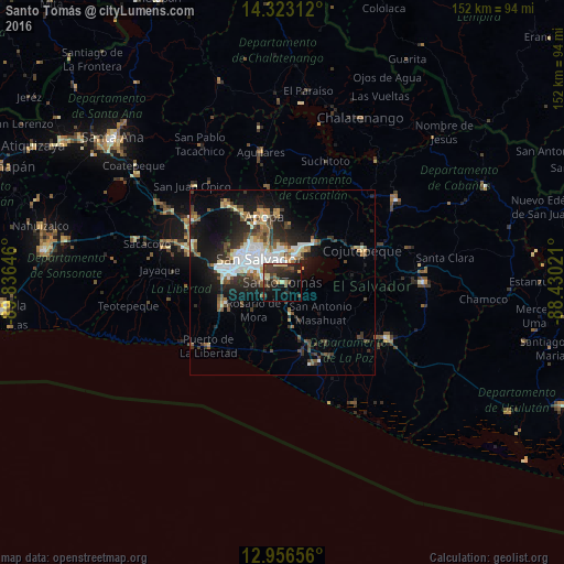
Analysis of Santo Tomás night lights 2016
Square area 10x10 km:
 0%
0%90-99
1.03%80-89
6.4%70-79
1.65%60-69
0%50-59
7.02%40-49
7.85%30-39
10.33%20-29
15.08%10-19
20.45%0-9
30.17%Square area 50x50 km:
2.3%90-99
2.65%80-89
1.6%70-79
1.03%60-69
1.62%50-59
2.25%40-49
2.38%30-39
2.98%20-29
4.26%10-19
9.12%0-9
69.83%Clear (daylight) street map image can be seen on geolist.org.
Map coordinates:
14° 19' 23.2" North, 89° 50' 11.3" West
13° 38' 27" North, 89° 7' 60" West
12° 57' 23.6" North, 88° 25' 48.8" West
Some cities around Santo Tomás sort by population:
• San Salvador
7.9 km =4.9 mi,  312°
312°
• Soyapango
7.8 km =4.8 mi,  354°
354°
• Delgado
10.1 km =6.3 mi,  336°
336°
• San Marcos
5.7 km =3.5 mi,  290°
290°
• Ilopango
7.2 km =4.5 mi,  20°
20°
• Panchimalco
5.9 km =3.7 mi,  238°
238°
• Olocuilta
8.1 km =5 mi,  167°
167°
• Rosario de Mora
10.9 km =6.8 mi,  228°
228°
3583183 (p: 14,581)
Sources (retrieved 2019-11-25):
» Earth at Night: Flat Maps 2012, 2016