Santiago Nonualco night lights from space
Night Light of Santiago Nonualco (La Paz) from space (El Salvador) Src. Average luminocity for 10x10km area is 2.3161% and for 50x50km: 5.9962%.
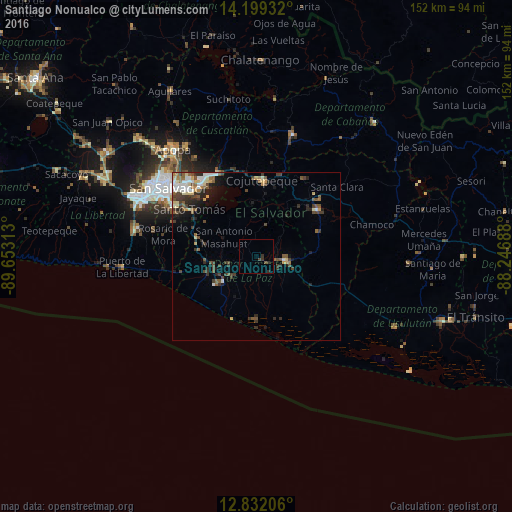
Analysis of Santiago Nonualco night lights 2016
Square area 10x10 km:
 0%
0%90-99
0%80-89
0%70-79
0%60-69
0%50-59
0.21%40-49
1.45%30-39
2.07%20-29
1.24%10-19
0%0-9
95.04%Square area 50x50 km:
0.67%90-99
0.93%80-89
0.81%70-79
0.37%60-69
0.64%50-59
1.19%40-49
1.36%30-39
1.49%20-29
1.7%10-19
2.05%0-9
88.79%Clear (daylight) street map image can be seen on geolist.org.
Map coordinates:
14° 11' 57.6" North, 89° 39' 11.3" West
13° 31' 0" North, 88° 57' 0" West
12° 49' 55.4" North, 88° 14' 48.8" West
Some cities around Santiago Nonualco sort by population:
• Cojutepeque
22.3 km =13.9 mi,  4°
4°
• San Vicente
20.8 km =12.9 mi,  51°
51°
• Zacatecoluca
9.2 km =5.7 mi,  101°
101°
• Ilopango
26.8 km =16.7 mi,  320°
320°
• Santo Tomás
24.1 km =15 mi,  304°
304°
• Olocuilta
19 km =11.8 mi,  288°
288°
• Apastepeque
24.5 km =15.2 mi, 47°
• El Rosario
8.9 km =5.5 mi,  256°
256°
3583196 (p: 9,490)
Sources (retrieved 2019-11-25):
» Earth at Night: Flat Maps 2012, 2016