Nueva Concepción night lights from space
Night Light of Nueva Concepción (Chalatenango) from space (El Salvador) Src. Average luminocity for 10x10km area is 1.3939% and for 50x50km: 1.4022%.
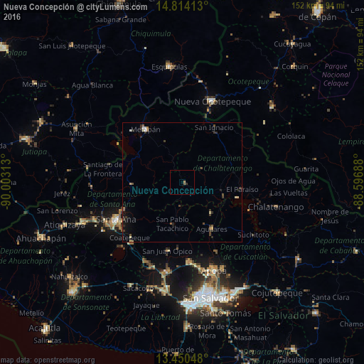
Analysis of Nueva Concepción night lights 2016
Square area 10x10 km:
 0%
0%90-99
0%80-89
0%70-79
0%60-69
0.87%50-59
0.87%40-49
0%30-39
0%20-29
0.87%10-19
0%0-9
97.4%Square area 50x50 km:
0.09%90-99
0.15%80-89
0.08%70-79
0.13%60-69
0.16%50-59
0.27%40-49
0.29%30-39
0.47%20-29
0.41%10-19
0.83%0-9
97.12%Clear (daylight) street map image can be seen on geolist.org.
Map coordinates:
14° 48' 50.9" North, 90° 0' 11.3" West
14° 7' 60" North, 89° 18' 0" West
13° 27' 1.7" North, 88° 35' 48.8" West
Some cities around Nueva Concepción sort by population:
• Santa Ana
32 km =19.9 mi,  241°
241°
• Quezaltepeque
33.7 km =20.9 mi,  174°
174°
• Aguilares
22.9 km =14.2 mi,  148°
148°
• Metapán
27.5 km =17.1 mi,  323°
323°
• Guazapa
31.6 km =19.6 mi, 154°
• El Congo
32.7 km =20.3 mi,  220°
220°
• San Juan Opico
29.3 km =18.2 mi,  192°
192°
• Coatepeque
31.7 km =19.7 mi, 224°
3584266 (p: 9,990)
Sources (retrieved 2019-11-25):
» Earth at Night: Flat Maps 2012, 2016