Antiguo Cuscatlán night lights from space
Night Light of Antiguo Cuscatlán (La Libertad) from space (El Salvador) Src. Average luminocity for 10x10km area is 61.0764% and for 50x50km: 15.9419%.

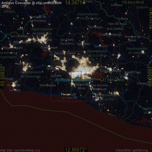
Analysis of Antiguo Cuscatlán night lights 2016
Square area 10x10 km:
 19.01%
90-99
22.73%80-89
4.75%70-79
1.24%60-69
1.24%50-59
3.72%40-49
4.75%30-39
9.71%20-29
17.77%10-19
15.08%0-9
0%Square area 50x50 km:
2.31%90-99
2.72%80-89
1.75%70-79
1.13%60-69
1.87%50-59
2.74%40-49
2.56%30-39
3.05%20-29
4.41%10-19
10.81%0-9
66.63%Clear (daylight) street map image can be seen on geolist.org.
Map coordinates:
14° 20' 49.7" North, 89° 57' 22.8" West
13° 39' 53.7" North, 89° 15' 11.5" West
12° 58' 50.6" North, 88° 33' 0.3" West
Some cities around Antiguo Cuscatlán sort by population:
• San Salvador
7.6 km =4.7 mi,  69°
69°
• Mejicanos
9.4 km =5.8 mi,  27°
27°
• Santa Tecla
3.2 km =2 mi,  294°
294°
• San Marcos
7.6 km =4.7 mi,  95°
95°
• Ayutuxtepeque
10.3 km =6.4 mi, 29°
• Zaragoza
9.2 km =5.7 mi,  204°
204°
• Panchimalco
9.8 km =6.1 mi,  126°
126°
• Nuevo Cuscatlán
2.2 km =1.4 mi,  215°
215°
3587362 (p: 33,767)
Sources (retrieved 2019-11-25):
» Earth at Night: Flat Maps 2012, 2016