Nguékhokh night lights from space
Night Light of Nguékhokh (Thiès) from space (Senegal) Src. Average luminocity for 10x10km area is 8.3831% and for 50x50km: 4.4019%.
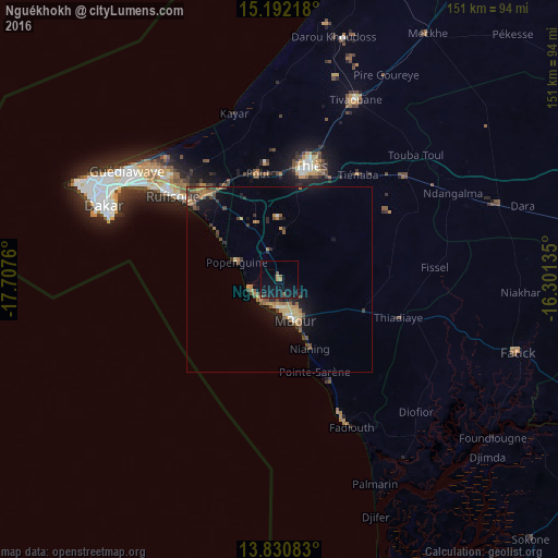
Analysis of Nguékhokh night lights 2016
Square area 10x10 km:
 0%
0%90-99
0%80-89
0%70-79
1.08%60-69
1.73%50-59
1.73%40-49
0.87%30-39
0.87%20-29
1.3%10-19
16.88%0-9
75.54%Square area 50x50 km:
0.05%90-99
0.25%80-89
0.39%70-79
0.84%60-69
0.97%50-59
0.8%40-49
1.04%30-39
0.82%20-29
0.67%10-19
3.54%0-9
90.62%Clear (daylight) street map image can be seen on geolist.org.
Map coordinates:
15° 11' 31.8" North, 17° 42' 27.4" West
14° 30' 45.2" North, 17° 0' 16.1" West
13° 49' 51" North, 16° 18' 4.9" West
Some cities around Nguékhokh sort by population:
• Pikine
50.1 km =31.1 mi,  303°
303°
• Thiès
31.9 km =19.8 mi,  15°
15°
• Thiès Nones
30.4 km =18.9 mi,  7°
7°
• Joal-Fadiout
42.6 km =26.5 mi,  154°
154°
• Pout
29.4 km =18.3 mi,  348°
348°
• Kayar
46.9 km =29.1 mi,  344°
344°
• Khombole
43.3 km =26.9 mi,  49°
49°
• Tiadiaye
34.5 km =21.4 mi,  108°
108°
2247381 (p: 17,885)
Sources (retrieved 2019-11-25):
» Earth at Night: Flat Maps 2012, 2016