Pout night lights from space
Night Light of Pout (Thiès) from space (Senegal) Src. Average luminocity for 10x10km area is 10.4442% and for 50x50km: 7.1644%.
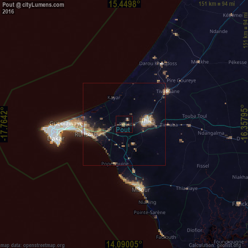
Analysis of Pout night lights 2016
Square area 10x10 km:
 0%
0%90-99
0.83%80-89
0%70-79
1.86%60-69
2.27%50-59
1.24%40-49
3.72%30-39
2.48%20-29
3.1%10-19
4.55%0-9
79.96%Square area 50x50 km:
0.42%90-99
0.79%80-89
0.52%70-79
1.18%60-69
1.09%50-59
1.17%40-49
1.7%30-39
1.5%20-29
1.89%10-19
5.47%0-9
84.26%Clear (daylight) street map image can be seen on geolist.org.
Map coordinates:
15° 26' 59.3" North, 17° 45' 51.1" West
14° 46' 15.6" North, 17° 3' 39.9" West
14° 5' 24.2" North, 16° 21' 28.6" West
Some cities around Pout sort by population:
• Dakar
42.1 km =26.2 mi,  258°
258°
• Pikine
35.4 km =22 mi,  268°
268°
• Thiès
14.7 km =9.1 mi,  81°
81°
• Thiès Nones
10.2 km =6.3 mi, 82°
• N’diareme limamoulaye
34.7 km =21.6 mi, 271°
• Nguékhokh
29.4 km =18.3 mi,  168°
168°
• Kayar
17.6 km =10.9 mi,  339°
339°
• Khombole
38.8 km =24.1 mi,  90°
90°
2246606 (p: 17,752)
Sources (retrieved 2019-11-25):
» Earth at Night: Flat Maps 2012, 2016