Mermoz Boabab night lights from space
Night Light of Mermoz Boabab (Dakar) from space (Senegal) Src. Average luminocity for 10x10km area is 74.4442% and for 50x50km: 11.1206%.
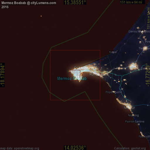
Analysis of Mermoz Boabab night lights 2016
Square area 10x10 km:
 40.08%
90-99
22.73%80-89
0.83%70-79
3.51%60-69
1.45%50-59
1.24%40-49
3.31%30-39
3.93%20-29
12.6%10-19
8.68%0-9
1.65%Square area 50x50 km:
2.98%90-99
2.52%80-89
0.77%70-79
1.48%60-69
0.7%50-59
0.93%40-49
1.04%30-39
1.31%20-29
3.7%10-19
5.66%0-9
78.91%Clear (daylight) street map image can be seen on geolist.org.
Map coordinates:
15° 23' 7.8" North, 18° 10' 44.2" West
14° 42' 23.4" North, 17° 28' 32.9" West
14° 1' 31.3" North, 16° 46' 21.7" West
Some cities around Mermoz Boabab sort by population:
• Dakar
3.7 km =2.3 mi,  112°
112°
• Pikine
11.2 km =7 mi,  54°
54°
• Thiès
59.8 km =37.2 mi,  81°
81°
• Thiès Nones
55.4 km =34.4 mi, 81°
• N’diareme limamoulaye
12.9 km =8 mi, 49°
• Nguékhokh
55.1 km =34.2 mi, 113°
• Pout
45.2 km =28.1 mi, 80°
• Kayar
45 km =28 mi,  58°
58°
8030383 (p: 15,000)
Sources (retrieved 2019-11-25):
» Earth at Night: Flat Maps 2012, 2016