Liptovský Hrádok night lights from space
Night Light of Liptovský Hrádok (Žilinský kraj) from space (Slovakia) Src. Average luminocity for 10x10km area is 2.8229% and for 50x50km: 0.754%.
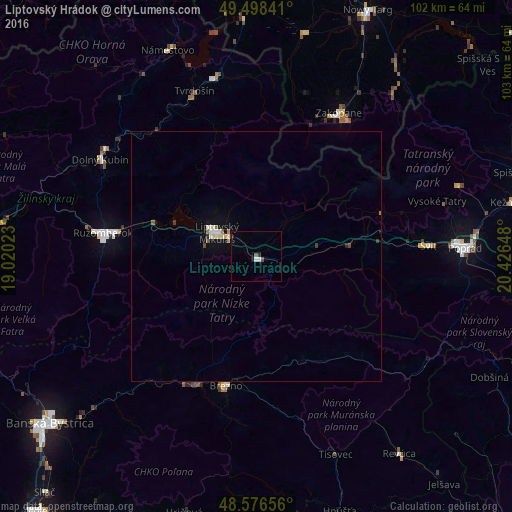
Analysis of Liptovský Hrádok night lights 2016
Square area 10x10 km:
 0.3%
0.3%90-99
0.89%80-89
0%70-79
0%60-69
0%50-59
0.89%40-49
0.3%30-39
0.3%20-29
0.74%10-19
0.45%0-9
96.13%Square area 50x50 km:
0.1%90-99
0.15%80-89
0.11%70-79
0%60-69
0.08%50-59
0.1%40-49
0.09%30-39
0.09%20-29
0.07%10-19
0.15%0-9
99.06%Clear (daylight) street map image can be seen on geolist.org.
Map coordinates:
49° 29' 54.3" North, 19° 1' 12.8" East
49° 2' 22.6" North, 19° 43' 24.1" East
48° 34' 35.6" North, 20° 25' 35.3" East
Some cities around Liptovský Hrádok sort by population:
• Ružomberok
30.6 km =19 mi,  277°
277°
• Zakopane, PL
33.2 km =20.6 mi,  29°
29°
• Brezno
26.9 km =16.7 mi,  193°
193°
• Dolný Kubín
35.9 km =22.3 mi,  301°
301°
• Tvrdošín
35.2 km =21.9 mi,  339°
339°
• Trstená
36.6 km =22.7 mi,  347°
347°
• Svit
35.3 km =21.9 mi,  86°
86°
• Čierny Balog
32.9 km =20.4 mi, 189°
3059053 (p: 7,572)
Sources (retrieved 2019-11-25):
» Earth at Night: Flat Maps 2012, 2016