Žalec night lights from space
Night Light of Žalec from space (Slovenia) Src. Average luminocity for 10x10km area is 10.689% and for 50x50km: 3.7181%.
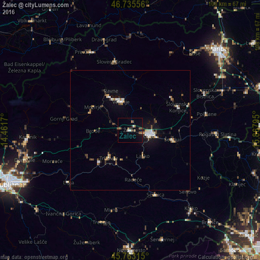
Analysis of Žalec night lights 2016
Square area 10x10 km:
100  0.3%
0.3%
90-99 1.49%
80-89 0.74%
70-79 1.04%
60-69 1.79%
50-59 3.57%
40-49 0.89%
30-39 0.89%
20-29 1.49%
10-19 4.76%
0-9 83.04%
0.3%90-99
1.49%80-89
0.74%70-79
1.04%60-69
1.79%50-59
3.57%40-49
0.89%30-39
0.89%20-29
1.49%10-19
4.76%0-9
83.04%Square area 50x50 km:
100 0.41%
90-99 0.64%
80-89 0.29%
70-79 0.31%
60-69 0.42%
50-59 0.61%
40-49 0.56%
30-39 0.56%
20-29 0.57%
10-19 1.92%
0-9 93.72%
0.41%90-99
0.64%80-89
0.29%70-79
0.31%60-69
0.42%50-59
0.61%40-49
0.56%30-39
0.56%20-29
0.57%10-19
1.92%0-9
93.72%Clear (daylight) street map image can be seen on geolist.org.
Map coordinates:
46° 44' 8" North, 14° 27' 42.1" East
46° 15' 5.4" North, 15° 9' 53.4" East
45° 45' 47.3" North, 15° 52' 4.6" East
Some cities around Žalec sort by population:
• Celje
7.7 km =4.8 mi,  107°
107°
• Polzela
8.3 km =5.2 mi,  295°
295°
• Vojnik
11.6 km =7.2 mi,  66°
66°
• Štore
12 km =7.5 mi, 106°
• Prebold
5.8 km =3.6 mi,  253°
253°
• Dobrna
10.7 km =6.6 mi,  26°
26°
• Tabor
11.4 km =7.1 mi,  261°
261°
• Braslovče
10.6 km =6.6 mi,  293°
293°
3186844 (p: 4,943)
Sources (retrieved 2019-11-25):
» Earth at Night: Flat Maps 2012, 2016