Zayukovo night lights from space
Night Light of Zayukovo (Kabardino-Balkariya Republic) from space (Russia) Src. Average luminocity for 10x10km area is 3.953% and for 50x50km: 4.4962%.
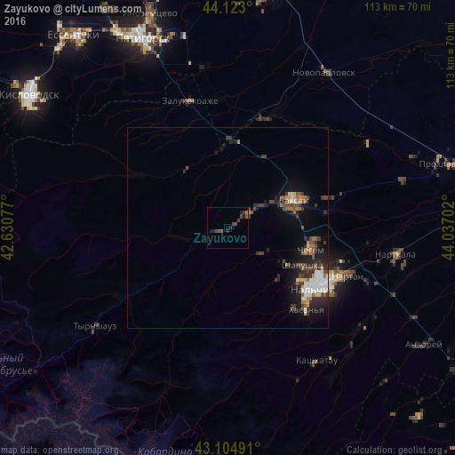
Analysis of Zayukovo night lights 2016
Square area 10x10 km:
 0%
0%90-99
0%80-89
0%70-79
0%60-69
0.61%50-59
1.21%40-49
2.27%30-39
1.97%20-29
2.12%10-19
2.12%0-9
89.7%Square area 50x50 km:
0.69%90-99
0.58%80-89
0.29%70-79
0.31%60-69
0.49%50-59
0.72%40-49
1.01%30-39
1.07%20-29
1.59%10-19
2.91%0-9
90.35%Clear (daylight) street map image can be seen on geolist.org.
Map coordinates:
44° 7' 22.8" North, 42° 37' 50.8" East
43° 36' 58" North, 43° 20' 2" East
43° 6' 17.7" North, 44° 2' 13.3" East
Some cities around Zayukovo sort by population:
• Baksan
18.2 km =11.3 mi,  63°
63°
• Dugulubgey
17.1 km =10.6 mi,  72°
72°
• Shalushka
20.9 km =13 mi,  116°
116°
• Islamey
11.8 km =7.3 mi, 55°
• Sarmakovo
18 km =11.2 mi,  323°
323°
• Malka
20.9 km =13 mi,  357°
357°
• Gundelen
13.2 km =8.2 mi,  260°
260°
• Kyzburun Pervyy
6.3 km =3.9 mi,  51°
51°
463966 (p: 10,559)
Sources (retrieved 2019-11-25):
» Earth at Night: Flat Maps 2012, 2016