Malka night lights from space
Night Light of Malka (Kabardino-Balkariya Republic) from space (Russia) Src. Average luminocity for 10x10km area is 1.5258% and for 50x50km: 2.3471%.
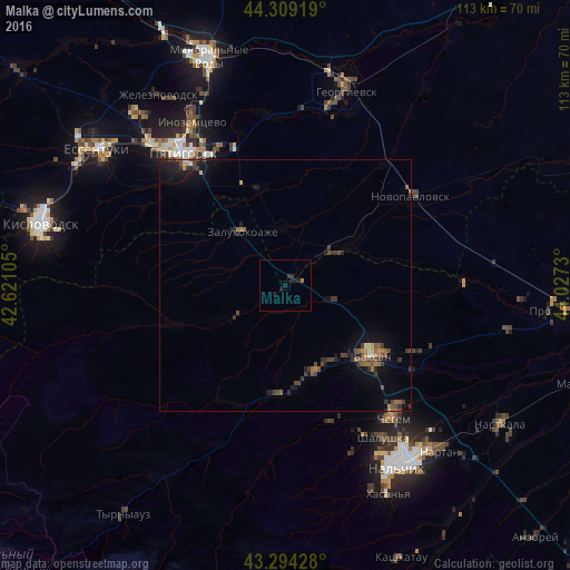
Analysis of Malka night lights 2016
Square area 10x10 km:
 0%
0%90-99
0%80-89
0%70-79
0%60-69
0.61%50-59
0%40-49
0%30-39
0.61%20-29
1.21%10-19
3.03%0-9
94.55%Square area 50x50 km:
0.02%90-99
0.1%80-89
0.13%70-79
0.23%60-69
0.38%50-59
0.48%40-49
0.74%30-39
0.64%20-29
0.67%10-19
2.14%0-9
94.46%Clear (daylight) street map image can be seen on geolist.org.
Map coordinates:
44° 18' 33.1" North, 42° 37' 15.8" East
43° 48' 14" North, 43° 19' 27" East
43° 17' 39.4" North, 44° 1' 38.3" East
Some cities around Malka sort by population:
• Baksan
21.4 km =13.3 mi,  127°
127°
• Dugulubgey
23.2 km =14.4 mi, 132°
• Islamey
17.7 km =11 mi,  143°
143°
• Zayukovo
20.9 km =13 mi,  177°
177°
• Zalukokoazhe
14.1 km =8.8 mi,  321°
321°
• Sarmakovo
11.9 km =7.4 mi,  236°
236°
• Kamennomostskoye
23.1 km =14.4 mi,  251°
251°
• Kyzburun Pervyy
17.9 km =11.1 mi,  161°
161°
530994 (p: 7,220)
Sources (retrieved 2019-11-25):
» Earth at Night: Flat Maps 2012, 2016