Ust’-Donetskiy night lights from space
Night Light of Ust’-Donetskiy (Rostov) from space (Russia) Src. Average luminocity for 10x10km area is 1.8839% and for 50x50km: 0.6065%.
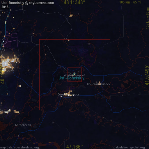
Analysis of Ust’-Donetskiy night lights 2016
Square area 10x10 km:
 0%
0%90-99
0%80-89
0.15%70-79
0.45%60-69
0.3%50-59
0.3%40-49
1.19%30-39
0.6%20-29
0%10-19
0.6%0-9
96.43%Square area 50x50 km:
0.02%90-99
0.05%80-89
0.07%70-79
0.05%60-69
0.13%50-59
0.15%40-49
0.18%30-39
0.15%20-29
0.07%10-19
0.11%0-9
99.02%Clear (daylight) street map image can be seen on geolist.org.
Map coordinates:
48° 6' 48.5" North, 40° 10' 7.3" East
47° 38' 30.8" North, 40° 52' 18.6" East
47° 9' 57.6" North, 41° 34' 29.8" East
Some cities around Ust’-Donetskiy sort by population:
• Shakhty
49.8 km =30.9 mi,  278°
278°
• Semikarakorsk
14.8 km =9.2 mi,  199°
199°
• Konstantinovsk
17.8 km =11.1 mi,  111°
111°
• Bagayevskaya
50.7 km =31.5 mi,  225°
225°
• Donskoy
52.6 km =32.7 mi,  241°
241°
• Kamenolomni
50 km =31.1 mi,  273°
273°
• Ayutinskiy
56.4 km =35 mi,  286°
286°
• Sinegorskiy
41.4 km =25.7 mi,  357°
357°
478132 (p: 11,357)
Sources (retrieved 2019-11-25):
» Earth at Night: Flat Maps 2012, 2016