Donskoy night lights from space
Night Light of Donskoy (Rostov) from space (Russia) Src. Average luminocity for 10x10km area is 9.7571% and for 50x50km: 4.2568%.
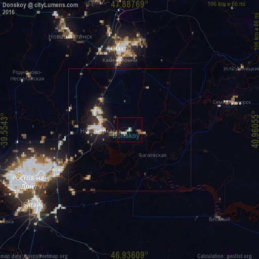
Analysis of Donskoy night lights 2016
Square area 10x10 km:
 1.7%
1.7%90-99
1.7%80-89
0.57%70-79
0.28%60-69
1.14%50-59
1.28%40-49
2.41%30-39
0.57%20-29
0.85%10-19
1.56%0-9
87.93%Square area 50x50 km:
0.6%90-99
0.76%80-89
0.4%70-79
0.38%60-69
0.36%50-59
0.43%40-49
0.62%30-39
0.53%20-29
1.26%10-19
3.21%0-9
91.45%Clear (daylight) street map image can be seen on geolist.org.
Map coordinates:
47° 53' 15.7" North, 39° 33' 15.5" East
47° 24' 50.5" North, 40° 15' 26.7" East
46° 56' 9.9" North, 40° 57' 38" East
Some cities around Donskoy sort by population:
• Shakhty
33 km =20.5 mi,  354°
354°
• Novocherkassk
12.5 km =7.8 mi,  273°
273°
• Aksay
34.1 km =21.2 mi,  239°
239°
• Bagayevskaya
14 km =8.7 mi,  135°
135°
• Kamenolomni
28.6 km =17.8 mi, 352°
• Mayskiy
33.4 km =20.8 mi,  339°
339°
• Krivyanskaya
7.1 km =4.4 mi,  254°
254°
• Starocherkasskaya
25.2 km =15.7 mi,  220°
220°
565300 (p: 13,627)
Sources (retrieved 2019-11-25):
» Earth at Night: Flat Maps 2012, 2016