Kamenolomni night lights from space
Night Light of Kamenolomni (Rostov) from space (Russia) Src. Average luminocity for 10x10km area is 38.0744% and for 50x50km: 7.4952%.
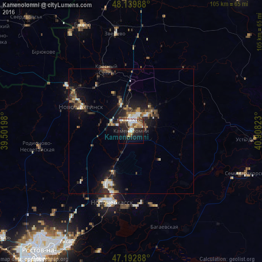
Analysis of Kamenolomni night lights 2016
Square area 10x10 km:
 7.59%
7.59%90-99
6.85%80-89
2.23%70-79
7.89%60-69
4.02%50-59
3.72%40-49
3.72%30-39
6.1%20-29
14.43%10-19
22.32%0-9
21.13%Square area 50x50 km:
0.78%90-99
1.12%80-89
0.54%70-79
1.05%60-69
0.92%50-59
0.92%40-49
1.26%30-39
1.48%20-29
2.66%10-19
5.88%0-9
83.4%Clear (daylight) street map image can be seen on geolist.org.
Map coordinates:
48° 8' 23.6" North, 39° 30' 7.1" East
47° 40' 6.7" North, 40° 12' 18.4" East
47° 11' 34.4" North, 40° 54' 29.6" East
Some cities around Kamenolomni sort by population:
• Shakhty
4.6 km =2.9 mi,  8°
8°
• Novoshakhtinsk
22.8 km =14.2 mi,  296°
296°
• Krasnyy Sulin
26.8 km =16.7 mi,  337°
337°
• Donskoy
28.6 km =17.8 mi,  172°
172°
• Mayskiy
8.3 km =5.2 mi,  291°
291°
• Ayutinskiy
13.4 km =8.3 mi, 341°
• Sokolovo-Kundryuchenskiy
26.8 km =16.7 mi,  313°
313°
• Talovyy
17 km =10.6 mi, 335°
553427 (p: 12,262)
Sources (retrieved 2019-11-25):
» Earth at Night: Flat Maps 2012, 2016