Smyshlyayevka night lights from space
Night Light of Smyshlyayevka (Samara Oblast) from space (Russia) Src. Average luminocity for 10x10km area is 31.1225% and for 50x50km: 16.5029%.
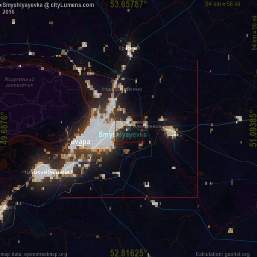
Analysis of Smyshlyayevka night lights 2016
Square area 10x10 km:
 4.8%
4.8%90-99
6.44%80-89
3.66%70-79
1.77%60-69
3.16%50-59
3.41%40-49
2.27%30-39
6.94%20-29
16.67%10-19
19.82%0-9
31.06%Square area 50x50 km:
4.63%90-99
3.41%80-89
1%70-79
1.12%60-69
1.94%50-59
1.53%40-49
1.43%30-39
2.68%20-29
4.55%10-19
7.95%0-9
69.76%Clear (daylight) street map image can be seen on geolist.org.
Map coordinates:
53° 39' 28.3" North, 49° 41' 15.4" East
53° 14' 20.9" North, 50° 23' 26.6" East
52° 48' 58.5" North, 51° 5' 37.9" East
Some cities around Smyshlyayevka sort by population:
• Samara
16.6 km =10.3 mi,  254°
254°
• Kinel’
15.9 km =9.9 mi,  95°
95°
• Roschinskiy
22.1 km =13.7 mi,  161°
161°
• Novosemeykino
14.8 km =9.2 mi,  350°
350°
• Krasnyy Yar
29 km =18 mi,  0°
0°
• Volzhskiy
27.9 km =17.3 mi,  319°
319°
• Petra-Dubrava
6.6 km =4.1 mi, 345°
• Rozhdestveno
22 km =13.7 mi,  269°
269°
491576 (p: 5,908)
Sources (retrieved 2019-11-25):
» Earth at Night: Flat Maps 2012, 2016