Volzhskiy night lights from space
Night Light of Volzhskiy (Samara Oblast) from space (Russia) Src. Average luminocity for 10x10km area is 12.9325% and for 50x50km: 10.068%.
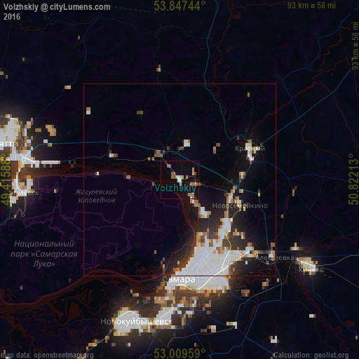
Analysis of Volzhskiy night lights 2016
Square area 10x10 km:
 0.26%
0.26%90-99
1.46%80-89
1.19%70-79
0.93%60-69
5.03%50-59
3.31%40-49
1.06%30-39
0%20-29
0.4%10-19
4.1%0-9
82.28%Square area 50x50 km:
3.05%90-99
1.88%80-89
0.59%70-79
0.58%60-69
1.23%50-59
1.07%40-49
0.79%30-39
1.35%20-29
2.65%10-19
4.84%0-9
81.98%Clear (daylight) street map image can be seen on geolist.org.
Map coordinates:
53° 50' 50.8" North, 49° 24' 57.2" East
53° 25' 50.1" North, 50° 7' 8.4" East
53° 0' 34.5" North, 50° 49' 19.7" East
Some cities around Volzhskiy sort by population:
• Pribrezhnyy
18.3 km =11.4 mi,  289°
289°
• Novosemeykino
17 km =10.6 mi,  113°
113°
• Krasnyy Yar
19.7 km =12.2 mi,  66°
66°
• Mirnyy
13.4 km =8.3 mi,  51°
51°
• Kurumoch
8.5 km =5.3 mi,  320°
320°
• Petra-Dubrava
22.2 km =13.8 mi,  132°
132°
• Berëza
9.9 km =6.2 mi,  7°
7°
• Rozhdestveno
21.8 km =13.5 mi,  190°
190°
472229 (p: 7,040)
Sources (retrieved 2019-11-25):
» Earth at Night: Flat Maps 2012, 2016