Rozhdestveno night lights from space
Night Light of Rozhdestveno (Samara Oblast) from space (Russia) Src. Average luminocity for 10x10km area is 18.9053% and for 50x50km: 18.2022%.
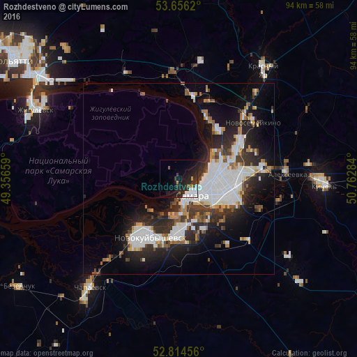
Analysis of Rozhdestveno night lights 2016
Square area 10x10 km:
 5.68%
5.68%90-99
3.41%80-89
0.25%70-79
0.63%60-69
0.63%50-59
1.52%40-49
1.14%30-39
3.03%20-29
10.98%10-19
18.06%0-9
54.67%Square area 50x50 km:
5.18%90-99
3.94%80-89
1.01%70-79
1.14%60-69
1.92%50-59
1.73%40-49
1.45%30-39
2.83%20-29
6.06%10-19
9.18%0-9
65.56%Clear (daylight) street map image can be seen on geolist.org.
Map coordinates:
53° 39' 22.3" North, 49° 21' 23.7" East
53° 14' 14.8" North, 50° 3' 35" East
52° 48' 52.4" North, 50° 45' 46.2" East
Some cities around Rozhdestveno sort by population:
• Samara
7.3 km =4.5 mi,  124°
124°
• Novokuybyshevsk
17.5 km =10.9 mi,  205°
205°
• Pribrezhnyy
30.8 km =19.1 mi,  334°
334°
• Novosemeykino
24.5 km =15.2 mi,  52°
52°
• Volzhskiy
21.8 km =13.5 mi,  10°
10°
• Kurumoch
28.1 km =17.5 mi,  356°
356°
• Petra-Dubrava
21.4 km =13.3 mi,  72°
72°
• Smyshlyayevka
22 km =13.7 mi,  89°
89°
501027 (p: 5,004)
Sources (retrieved 2019-11-25):
» Earth at Night: Flat Maps 2012, 2016