Shushary night lights from space
Night Light of Shushary (St.-Petersburg) from space (Russia) Src. Average luminocity for 10x10km area is 93.7446% and for 50x50km: 45.1717%.
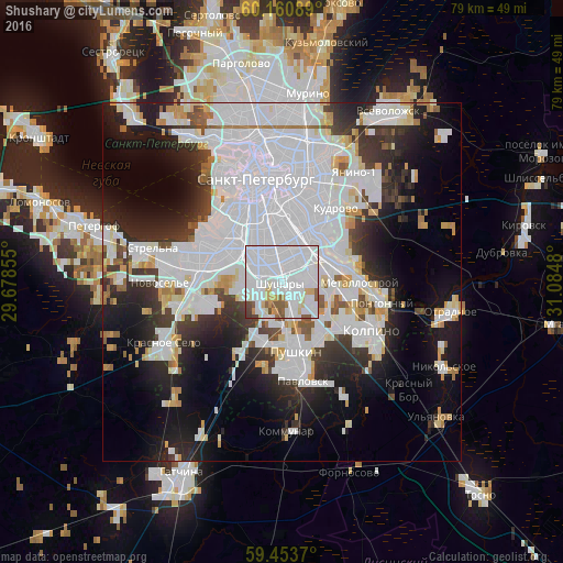
Analysis of Shushary night lights 2016
Square area 10x10 km:
 68.61%
90-99
14.72%80-89
3.9%70-79
4%60-69
1.19%50-59
5.3%40-49
1.62%30-39
0.65%20-29
0%10-19
0%0-9
0%Square area 50x50 km:
22.66%90-99
9.07%80-89
2.74%70-79
2.79%60-69
1.64%50-59
2.04%40-49
1.99%30-39
4.54%20-29
7.96%10-19
12.81%0-9
31.75%Clear (daylight) street map image can be seen on geolist.org.
Map coordinates:
60° 9' 39.2" North, 29° 40' 42.8" East
59° 48' 33" North, 30° 22' 54" East
59° 27' 13.3" North, 31° 5' 5.3" East
Some cities around Shushary sort by population:
• Pushkin
10.6 km =6.6 mi,  175°
175°
• Dachnoye
7.9 km =4.9 mi,  297°
297°
• Rybatskoye
7.4 km =4.6 mi,  62°
62°
• Uritsk
12 km =7.5 mi,  285°
285°
• Kupchino
5 km =3.1 mi,  343°
343°
• Obukhovo
5.5 km =3.4 mi,  45°
45°
• Avtovo
9.5 km =5.9 mi,  317°
317°
• Metallostroy
9.3 km =5.8 mi,  95°
95°
493316 (p: 15,503)
Sources (retrieved 2019-11-25):
» Earth at Night: Flat Maps 2012, 2016