Serafimovskiy night lights from space
Night Light of Serafimovskiy (Bashkortostan Republic) from space (Russia) Src. Average luminocity for 10x10km area is 2.4055% and for 50x50km: 3.4177%.
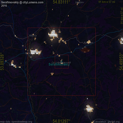
Analysis of Serafimovskiy night lights 2016
Square area 10x10 km:
 0%
0%90-99
0%80-89
0%70-79
0.96%60-69
0.48%50-59
1.08%40-49
0.6%30-39
0.48%20-29
0%10-19
0%0-9
96.41%Square area 50x50 km:
0.66%90-99
0.55%80-89
0.2%70-79
0.36%60-69
0.33%50-59
0.44%40-49
0.52%30-39
0.26%20-29
0.39%10-19
3.51%0-9
92.76%Clear (daylight) street map image can be seen on geolist.org.
Map coordinates:
54° 49' 52" North, 53° 5' 35.8" East
54° 25' 26.7" North, 53° 47' 47" East
54° 0' 46.7" North, 54° 29' 58.3" East
Some cities around Serafimovskiy sort by population:
• Oktyabr’skiy
22 km =13.7 mi,  286°
286°
• Tuymazy
21.1 km =13.1 mi,  344°
344°
• Belebey
40 km =24.9 mi,  148°
148°
• Bavly
34.9 km =21.7 mi,  264°
264°
• Kandry
26.1 km =16.2 mi,  52°
52°
• Urussu
28.9 km =18 mi,  311°
311°
• Subkhankulovo
14.9 km =9.3 mi,  3°
3°
• Sharan
45.6 km =28.3 mi,  16°
16°
496954 (p: 10,360)
Sources (retrieved 2019-11-25):
» Earth at Night: Flat Maps 2012, 2016