Karabudakhkent night lights from space
Night Light of Karabudakhkent (Dagestan) from space (Russia) Src. Average luminocity for 10x10km area is 17.8424% and for 50x50km: 7.6241%.
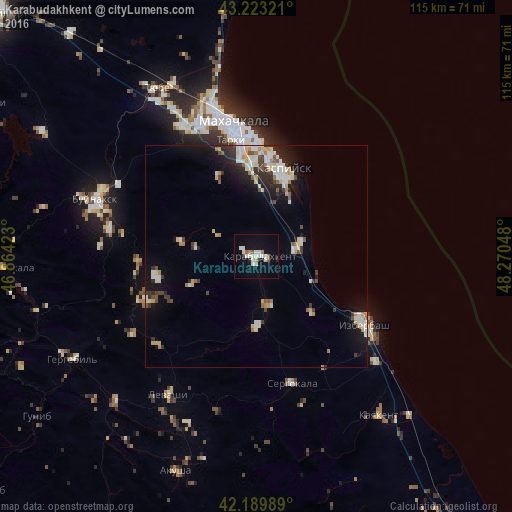
Analysis of Karabudakhkent night lights 2016
Square area 10x10 km:
 3.03%
3.03%90-99
6.67%80-89
0%70-79
0.76%60-69
1.06%50-59
2.42%40-49
0%30-39
0.61%20-29
1.06%10-19
12.27%0-9
72.12%Square area 50x50 km:
0.92%90-99
1.96%80-89
0.69%70-79
0.77%60-69
0.71%50-59
0.64%40-49
0.68%30-39
1.06%20-29
1.77%10-19
4.8%0-9
86.01%Clear (daylight) street map image can be seen on geolist.org.
Map coordinates:
43° 13' 23.6" North, 46° 51' 51.2" East
42° 42' 31.3" North, 47° 34' 2.5" East
42° 11' 23.6" North, 48° 16' 13.7" East
Some cities around Karabudakhkent sort by population:
• Kaspiysk
20.1 km =12.5 mi,  16°
16°
• Izberbash
28.8 km =17.9 mi,  122°
122°
• Tarki
26.8 km =16.7 mi,  347°
347°
• Gubden
15.6 km =9.7 mi,  180°
180°
• Novyy Khushet
21.2 km =13.2 mi,  358°
358°
• Nizhniy Dzhengutay
26.4 km =16.4 mi,  267°
267°
• Manas
9.3 km =5.8 mi,  77°
77°
• Dorgeli
22.8 km =14.2 mi,  258°
258°
552953 (p: 13,207)
Sources (retrieved 2019-11-25):
» Earth at Night: Flat Maps 2012, 2016