Lakhdenpokh’ya night lights from space
Night Light of Lakhdenpokh’ya (Karelia) from space (Russia) Src. Average luminocity for 10x10km area is 10.3571% and for 50x50km: 2.861%.
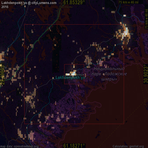
Analysis of Lakhdenpokh’ya night lights 2016
Square area 10x10 km:
 1.66%
1.66%90-99
1.24%80-89
1.66%70-79
1.45%60-69
3.11%50-59
0%40-49
0.41%30-39
0%20-29
0%10-19
1.76%0-9
88.72%Square area 50x50 km:
0.08%90-99
0.07%80-89
0.08%70-79
0.08%60-69
0.25%50-59
0.39%40-49
0.78%30-39
3.23%20-29
0.36%10-19
0.65%0-9
94.02%Clear (daylight) street map image can be seen on geolist.org.
Map coordinates:
61° 51' 11.8" North, 29° 29' 45.8" East
61° 31' 11.3" North, 30° 11' 57" East
61° 10' 57.8" North, 30° 54' 8.3" East
Some cities around Lakhdenpokh’ya sort by population:
• Savonlinna, FI
79.7 km =49.5 mi,  299°
299°
• Sortavala
34.4 km =21.4 mi,  51°
51°
• Priozërsk
53.6 km =33.3 mi,  184°
184°
• Svetogorsk
84.5 km =52.5 mi,  237°
237°
• Pitkyaranta
68.1 km =42.3 mi,  84°
84°
• Kitee, FI
64.6 km =40.1 mi,  357°
357°
• Kerimäki, FI
65 km =40.4 mi,  311°
311°
• Ruokolahti, FI
77.3 km =48 mi,  250°
250°
537147 (p: 8,448)
Sources (retrieved 2019-11-25):
» Earth at Night: Flat Maps 2012, 2016