Koltushi night lights from space
Night Light of Koltushi (Leningradskaya Oblast') from space (Russia) Src. Average luminocity for 10x10km area is 45.9913% and for 50x50km: 42.7975%.
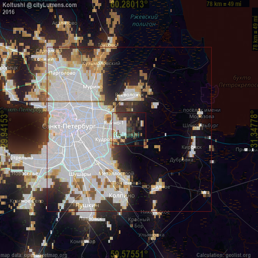
Analysis of Koltushi night lights 2016
Square area 10x10 km:
 10.71%
90-99
12.55%80-89
3.79%70-79
5.52%60-69
1.95%50-59
0.87%40-49
6.82%30-39
11.36%20-29
15.58%10-19
16.67%0-9
14.18%Square area 50x50 km:
22.27%90-99
8.78%80-89
3.15%70-79
3.03%60-69
2.22%50-59
1.55%40-49
1.78%30-39
3.33%20-29
4.75%10-19
7.11%0-9
42.03%Clear (daylight) street map image can be seen on geolist.org.
Map coordinates:
60° 16' 48.5" North, 29° 56' 29.5" East
59° 55' 46.9" North, 30° 38' 40.7" East
59° 34' 31.8" North, 31° 20' 52" East
Some cities around Koltushi sort by population:
• Krasnogvargeisky
10.6 km =6.6 mi,  297°
297°
• Centralniy
15.8 km =9.8 mi,  270°
270°
• Rybatskoye
12.9 km =8 mi,  219°
219°
• Vsevolozhsk
9.6 km =6 mi,  9°
9°
• Obukhovo
14.4 km =8.9 mi,  228°
228°
• Metallostroy
15.3 km =9.5 mi,  200°
200°
• Imeni Sverdlova
14.9 km =9.3 mi,  175°
175°
• Romanovka
13.3 km =8.3 mi,  16°
16°
546055 (p: 10,000)
Sources (retrieved 2019-11-25):
» Earth at Night: Flat Maps 2012, 2016