Imeni Sverdlova night lights from space
Night Light of Imeni Sverdlova (Leningradskaya Oblast') from space (Russia) Src. Average luminocity for 10x10km area is 30.8366% and for 50x50km: 33.8321%.
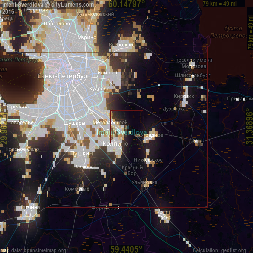
Analysis of Imeni Sverdlova night lights 2016
Square area 10x10 km:
 6.6%
6.6%90-99
7.36%80-89
5.63%70-79
2.81%60-69
0.54%50-59
1.84%40-49
4.55%30-39
3.46%20-29
9.52%10-19
13.42%0-9
44.26%Square area 50x50 km:
19.04%90-99
5.87%80-89
2%70-79
1.93%60-69
0.98%50-59
1.23%40-49
1.38%30-39
2.88%20-29
4.25%10-19
7.67%0-9
52.76%Clear (daylight) street map image can be seen on geolist.org.
Map coordinates:
60° 8' 52.7" North, 29° 57' 45.8" East
59° 47' 46" North, 30° 39' 57" East
59° 26' 25.8" North, 31° 22' 8.3" East
Some cities around Imeni Sverdlova sort by population:
• Kolpino
6.6 km =4.1 mi,  220°
220°
• Rybatskoye
10.5 km =6.5 mi,  297°
297°
• Obukhovo
13.1 km =8.1 mi,  293°
293°
• Metallostroy
6.6 km =4.1 mi,  274°
274°
• Otradnoye
8.8 km =5.5 mi,  103°
103°
• Nikol’skoye
12.5 km =7.8 mi,  147°
147°
• Koltushi
14.9 km =9.3 mi,  355°
355°
• Pontonnyy
3 km =1.9 mi,  249°
249°
556511 (p: 9,151)
Sources (retrieved 2019-11-25):
» Earth at Night: Flat Maps 2012, 2016