Karagach night lights from space
Night Light of Karagach (Kabardino-Balkariya Republic) from space (Russia) Src. Average luminocity for 10x10km area is 1.1864% and for 50x50km: 1.828%.
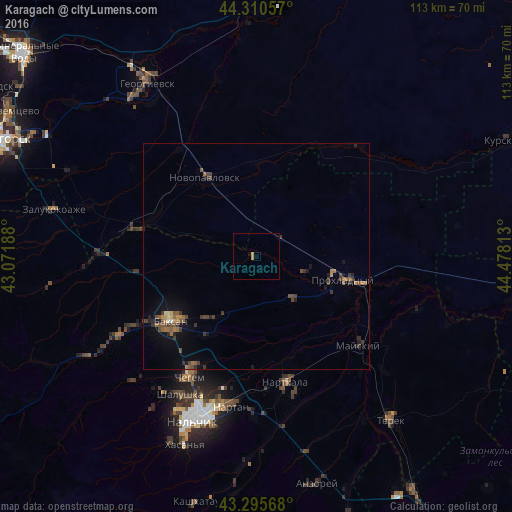
Analysis of Karagach night lights 2016
Square area 10x10 km:
 0%
0%90-99
0%80-89
0%70-79
1.21%60-69
0%50-59
0%40-49
0%30-39
0%20-29
0%10-19
0.61%0-9
98.18%Square area 50x50 km:
0.01%90-99
0.07%80-89
0.08%70-79
0.24%60-69
0.32%50-59
0.47%40-49
0.52%30-39
0.63%20-29
0.42%10-19
0.98%0-9
96.25%Clear (daylight) street map image can be seen on geolist.org.
Map coordinates:
44° 18' 38.1" North, 43° 4' 18.8" East
43° 48' 19" North, 43° 46' 30" East
43° 17' 44.4" North, 44° 28' 41.3" East
Some cities around Karagach sort by population:
• Prokhladnyy
21.1 km =13.1 mi,  104°
104°
• Baksan
23.1 km =14.4 mi,  235°
235°
• Nartkala
28.2 km =17.5 mi,  167°
167°
• Novopavlovsk
20.8 km =12.9 mi,  327°
327°
• Dugulubgey
24.9 km =15.5 mi,  230°
230°
• Chegem Vtoroy
27.2 km =16.9 mi,  211°
211°
• Baksanenok
16.1 km =10 mi,  216°
216°
• Altud
11.8 km =7.3 mi,  141°
141°
552895 (p: 5,870)
Sources (retrieved 2019-11-25):
» Earth at Night: Flat Maps 2012, 2016