Borovoy night lights from space
Night Light of Borovoy (Kemerovo Oblast) from space (Russia) Src. Average luminocity for 10x10km area is 75.6541% and for 50x50km: 22.5907%.
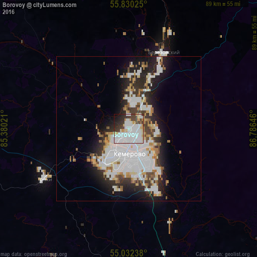
Analysis of Borovoy night lights 2016
Square area 10x10 km:
 33.58%
90-99
24.06%80-89
6.39%70-79
4.14%60-69
1.13%50-59
0.13%40-49
8.77%30-39
8.9%20-29
7.52%10-19
4.64%0-9
0.75%Square area 50x50 km:
7.67%90-99
5.45%80-89
1.94%70-79
1.75%60-69
1.79%50-59
1.77%40-49
1.63%30-39
2.65%20-29
5.34%10-19
7.95%0-9
62.07%Clear (daylight) street map image can be seen on geolist.org.
Map coordinates:
55° 49' 48.9" North, 85° 22' 48.8" East
55° 25' 60" North, 86° 4' 60" East
55° 1' 56.6" North, 86° 47' 11.3" East
Some cities around Borovoy sort by population:
• Kemerovo
11.1 km =6.9 mi,  180°
180°
• Berëzovskiy
19.9 km =12.4 mi,  21°
21°
• Topki
34.3 km =21.3 mi,  239°
239°
• Kedrovka
9.8 km =6.1 mi,  4°
4°
• Yashkino
64 km =39.8 mi,  319°
319°
• Yagunovskiy
18 km =11.2 mi,  201°
201°
• Promyshlennovskiy
9.2 km =5.7 mi,  52°
52°
• Pioner
15.4 km =9.6 mi,  212°
212°
1508894 (p: 5,942)
Sources (retrieved 2019-11-25):
» Earth at Night: Flat Maps 2012, 2016