Pioner night lights from space
Night Light of Pioner (Kemerovo Oblast) from space (Russia) Src. Average luminocity for 10x10km area is 66.5287% and for 50x50km: 20.4147%.
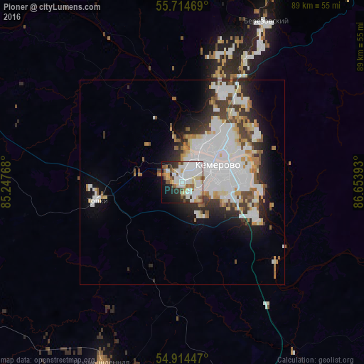
Analysis of Pioner night lights 2016
Square area 10x10 km:
 23.8%
23.8%90-99
20.45%80-89
8.85%70-79
2.51%60-69
4.43%50-59
7.06%40-49
2.75%30-39
4.07%20-29
9.09%10-19
12.2%0-9
4.78%Square area 50x50 km:
7.3%90-99
5.04%80-89
1.73%70-79
1.54%60-69
1.47%50-59
1.57%40-49
1.52%30-39
2.36%20-29
3.52%10-19
5.98%0-9
67.96%Clear (daylight) street map image can be seen on geolist.org.
Map coordinates:
55° 42' 52.9" North, 85° 14' 51.6" East
55° 18' 59.8" North, 85° 57' 2.9" East
54° 54' 52.1" North, 86° 39' 14.1" East
Some cities around Pioner sort by population:
• Kemerovo
8.6 km =5.3 mi,  77°
77°
• Berëzovskiy
35.2 km =21.9 mi,  26°
26°
• Topki
21.6 km =13.4 mi,  258°
258°
• Kedrovka
24.5 km =15.2 mi,  21°
21°
• Promyshlennaya
48.8 km =30.3 mi,  204°
204°
• Yagunovskiy
4.1 km =2.5 mi,  155°
155°
• Promyshlennovskiy
24.3 km =15.1 mi,  40°
40°
• Borovoy
15.4 km =9.6 mi, 32°
1494955 (p: 6,015)
Sources (retrieved 2019-11-25):
» Earth at Night: Flat Maps 2012, 2016