Yashkino night lights from space
Night Light of Yashkino (Kemerovo Oblast) from space (Russia) Src. Average luminocity for 10x10km area is 7.8722% and for 50x50km: 1.3044%.
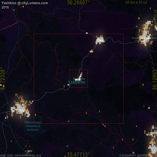
Analysis of Yashkino night lights 2016
Square area 10x10 km:
 2.01%
2.01%90-99
1.5%80-89
1.38%70-79
0.13%60-69
0%50-59
0.75%40-49
0.75%30-39
0%20-29
1.88%10-19
0.25%0-9
91.35%Square area 50x50 km:
0.3%90-99
0.32%80-89
0.09%70-79
0.07%60-69
0.12%50-59
0.1%40-49
0.11%30-39
0.02%20-29
0.07%10-19
0.97%0-9
97.82%Clear (daylight) street map image can be seen on geolist.org.
Map coordinates:
56° 15' 57.9" North, 84° 43' 24.2" East
55° 52' 25" North, 85° 25' 35.4" East
55° 28' 37.7" North, 86° 7' 46.7" East
Some cities around Yashkino sort by population:
• Yurga
37.7 km =23.4 mi,  243°
243°
• Anzhero-Sudzhensk
44 km =27.3 mi,  58°
58°
• Berëzovskiy
57.2 km =35.5 mi,  122°
122°
• Topki
67.4 km =41.9 mi,  169°
169°
• Tayga
24.4 km =15.2 mi,  29°
29°
• Kedrovka
57.3 km =35.6 mi,  133°
133°
• Promyshlennovskiy
65.1 km =40.5 mi, 131°
• Borovoy
64 km =39.8 mi,  139°
139°
1486298 (p: 15,197)
Sources (retrieved 2019-11-25):
» Earth at Night: Flat Maps 2012, 2016