Abagur night lights from space
Night Light of Abagur (Kemerovo Oblast) from space (Russia) Src. Average luminocity for 10x10km area is 26.8548% and for 50x50km: 12.5614%.
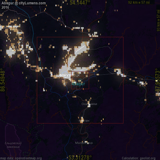
Analysis of Abagur night lights 2016
Square area 10x10 km:
 4.42%
4.42%90-99
4.42%80-89
1.01%70-79
2.53%60-69
2.02%50-59
4.17%40-49
3.16%30-39
4.55%20-29
17.3%10-19
23.74%0-9
32.7%Square area 50x50 km:
3.19%90-99
2.93%80-89
0.9%70-79
0.79%60-69
0.85%50-59
0.97%40-49
1.06%30-39
2.05%20-29
4.32%10-19
7.37%0-9
75.56%Clear (daylight) street map image can be seen on geolist.org.
Map coordinates:
54° 8' 40.9" North, 86° 32' 58.1" East
53° 43' 50.9" North, 87° 15' 9.4" East
53° 18' 46" North, 87° 57' 20.6" East
Some cities around Abagur sort by population:
• Novokuznetsk
9.8 km =6.1 mi,  286°
286°
• Prokop’yevsk
40.1 km =24.9 mi,  299°
299°
• Kiselëvsk
48.3 km =30 mi,  306°
306°
• Mezhdurechensk
53.3 km =33.1 mi,  94°
94°
• Osinniki
13.8 km =8.6 mi,  149°
149°
• Myski
36.2 km =22.5 mi, 93°
• Kaltan
21.8 km =13.5 mi,  181°
181°
• Tayzhina
14 km =8.7 mi,  120°
120°
1512238 (p: 6,530)
Sources (retrieved 2019-11-25):
» Earth at Night: Flat Maps 2012, 2016