Novo Miloševo night lights from space
Night Light of Novo Miloševo (Vojvodina) from space (Serbia) Src. Average luminocity for 10x10km area is 4.5636% and for 50x50km: 5.097%.
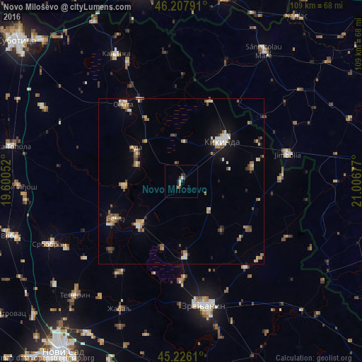
Analysis of Novo Miloševo night lights 2016
Square area 10x10 km:
 0.3%
0.3%90-99
1.36%80-89
0.15%70-79
0.61%60-69
0%50-59
0%40-49
1.67%30-39
0.76%20-29
2.42%10-19
0%0-9
92.73%Square area 50x50 km:
0.53%90-99
0.68%80-89
0.58%70-79
0.73%60-69
0.64%50-59
0.82%40-49
0.77%30-39
0.63%20-29
0.6%10-19
1.8%0-9
92.23%Clear (daylight) street map image can be seen on geolist.org.
Map coordinates:
46° 12' 28.5" North, 19° 36' 1.9" East
45° 43' 9" North, 20° 18' 13.1" East
45° 13' 34" North, 21° 0' 24.4" East
Some cities around Novo Miloševo sort by population:
• Kikinda
17.6 km =10.9 mi,  45°
45°
• Bečej
23.9 km =14.9 mi,  241°
241°
• Senta
29.1 km =18.1 mi,  322°
322°
• Bačko Petrovo Selo
17.5 km =10.9 mi,  265°
265°
• Mol
14.2 km =8.8 mi,  290°
290°
• Melenci
22.5 km =14 mi,  176°
176°
• Mokrin
25.3 km =15.7 mi,  19°
19°
• Čoka
27.8 km =17.3 mi,  333°
333°
787584 (p: 7,805)
Sources (retrieved 2019-11-25):
» Earth at Night: Flat Maps 2012, 2016