Čoka night lights from space
Night Light of Čoka (Vojvodina) from space (Serbia) Src. Average luminocity for 10x10km area is 11.3586% and for 50x50km: 3.4752%.
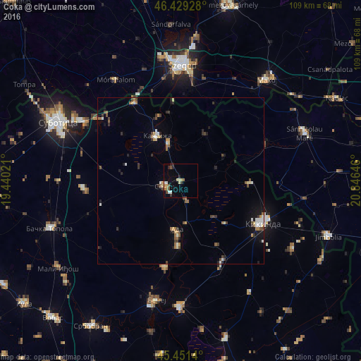
Analysis of Čoka night lights 2016
Square area 10x10 km:
 1.34%
1.34%90-99
1.04%80-89
1.93%70-79
2.23%60-69
0.74%50-59
1.19%40-49
1.64%30-39
1.34%20-29
2.23%10-19
1.49%0-9
84.82%Square area 50x50 km:
0.37%90-99
0.46%80-89
0.35%70-79
0.38%60-69
0.46%50-59
0.45%40-49
0.56%30-39
0.64%20-29
0.56%10-19
1.31%0-9
94.48%Clear (daylight) street map image can be seen on geolist.org.
Map coordinates:
46° 25' 45.4" North, 19° 26' 24.8" East
45° 56' 33" North, 20° 8' 36" East
45° 27' 5" North, 20° 50' 47.3" East
Some cities around Čoka sort by population:
• Kikinda
27.9 km =17.3 mi,  116°
116°
• Senta
5.4 km =3.4 mi,  251°
251°
• Kanjiža
15.6 km =9.7 mi,  332°
332°
• Bačko Petrovo Selo
26.7 km =16.6 mi,  190°
190°
• Novi Kneževac
12.4 km =7.7 mi,  344°
344°
• Mol
19.8 km =12.3 mi,  182°
182°
• Novo Miloševo
27.8 km =17.3 mi,  153°
153°
• Mokrin
20.8 km =12.9 mi,  92°
92°
791900 (p: 5,414)
Sources (retrieved 2019-11-25):
» Earth at Night: Flat Maps 2012, 2016