Lapovo night lights from space
Night Light of Lapovo (Central Serbia) from space (Serbia) Src. Average luminocity for 10x10km area is 13.05% and for 50x50km: 6.2094%.
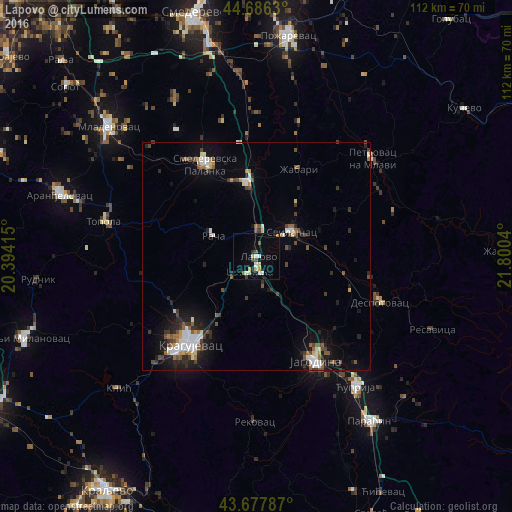
Analysis of Lapovo night lights 2016
Square area 10x10 km:
 1.52%
1.52%90-99
2.73%80-89
1.21%70-79
2.12%60-69
0.91%50-59
0.91%40-49
1.52%30-39
0.61%20-29
0.91%10-19
2.58%0-9
85%Square area 50x50 km:
0.94%90-99
1.02%80-89
0.44%70-79
0.43%60-69
0.67%50-59
0.81%40-49
1.08%30-39
1.01%20-29
1.38%10-19
3.69%0-9
88.51%Clear (daylight) street map image can be seen on geolist.org.
Map coordinates:
44° 41' 10.7" North, 20° 23' 38.9" East
44° 11' 3.3" North, 21° 5' 50.2" East
43° 40' 40.3" North, 21° 48' 1.4" East
Some cities around Lapovo sort by population:
• Kragujevac
23.6 km =14.7 mi,  217°
217°
• Požarevac
49.1 km =30.5 mi,  8°
8°
• Jagodina
26.5 km =16.5 mi,  150°
150°
• Smederevska Palanka
23 km =14.3 mi,  331°
331°
• Aranđelovac
44.9 km =27.9 mi,  287°
287°
• Gornji Milanovac
53.7 km =33.4 mi,  250°
250°
• Ćuprija
35.9 km =22.3 mi,  142°
142°
• Paraćin
43.7 km =27.2 mi, 145°
788792 (p: 7,422)
Sources (retrieved 2019-11-25):
» Earth at Night: Flat Maps 2012, 2016