Oţelu Roşu night lights from space
Night Light of Oţelu Roşu (Caraş-Severin) from space (Romania) Src. Average luminocity for 10x10km area is 1.8273% and for 50x50km: 0.6766%.
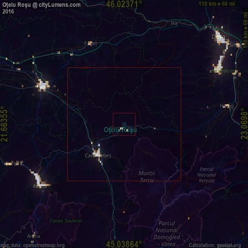
Analysis of Oţelu Roşu night lights 2016
Square area 10x10 km:
 0.3%
0.3%90-99
0.3%80-89
0.61%70-79
0%60-69
0.61%50-59
0%40-49
0.45%30-39
0.15%20-29
0%10-19
0%0-9
97.58%Square area 50x50 km:
0.1%90-99
0.18%80-89
0.06%70-79
0.1%60-69
0.05%50-59
0%40-49
0.1%30-39
0.05%20-29
0.06%10-19
0.12%0-9
99.18%Clear (daylight) street map image can be seen on geolist.org.
Map coordinates:
46° 1' 25.4" North, 21° 39' 48.8" East
45° 31' 60" North, 22° 22' 0" East
45° 2' 19.1" North, 23° 4' 11.3" East
Some cities around Oţelu Roşu sort by population:
• Reşiţa
45.4 km =28.2 mi,  235°
235°
• Hunedoara
48 km =29.8 mi,  59°
59°
• Lugoj
40 km =24.9 mi,  295°
295°
• Caransebeş
17.5 km =10.9 mi,  222°
222°
• Bocşa
54.3 km =33.7 mi,  250°
250°
• Călan
52.9 km =32.9 mi,  65°
65°
• Haţeg
46.3 km =28.8 mi,  78°
78°
• Făget
38 km =23.6 mi,  337°
337°
671603 (p: 11,482)
Sources (retrieved 2019-11-25):
» Earth at Night: Flat Maps 2012, 2016