Bolintin Vale night lights from space
Night Light of Bolintin Vale (Giurgiu) from space (Romania) Src. Average luminocity for 10x10km area is 15.4016% and for 50x50km: 14.7031%.
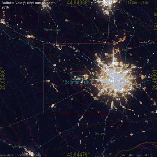
Analysis of Bolintin Vale night lights 2016
Square area 10x10 km:
 0.48%
0.48%90-99
1.43%80-89
1.75%70-79
1.43%60-69
4.13%50-59
1.27%40-49
3.02%30-39
3.33%20-29
4.76%10-19
14.29%0-9
64.13%Square area 50x50 km:
2.65%90-99
3.01%80-89
1.41%70-79
1.65%60-69
1.83%50-59
1.92%40-49
2.4%30-39
2.42%20-29
3.77%10-19
6.86%0-9
72.08%Clear (daylight) street map image can be seen on geolist.org.
Map coordinates:
44° 56' 55.2" North, 25° 3' 16.8" East
44° 26' 56" North, 25° 45' 28" East
43° 56' 41.2" North, 26° 27' 39.3" East
Some cities around Bolintin Vale sort by population:
• Joiţa
9.1 km =5.7 mi,  56°
56°
• Roata de Jos
17.5 km =10.9 mi,  256°
256°
• Chiajna
17.2 km =10.7 mi,  85°
85°
• Ulmi
4.6 km =2.9 mi,  23°
23°
• Domneşti-Sârbi
14.6 km =9.1 mi,  120°
120°
• Găiseni
11.6 km =7.2 mi,  309°
309°
• Domnești
13.7 km =8.5 mi,  113°
113°
• Tărtăşeşti
14.9 km =9.3 mi, 16°
684266 (p: 11,700)
Sources (retrieved 2019-11-25):
» Earth at Night: Flat Maps 2012, 2016