Joiţa night lights from space
Night Light of Joiţa (Giurgiu) from space (Romania) Src. Average luminocity for 10x10km area is 23.1524% and for 50x50km: 22.4689%.
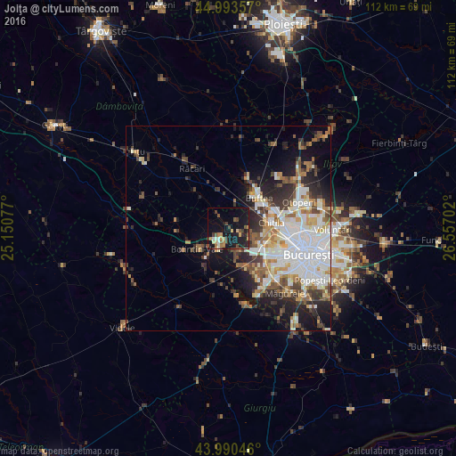
Analysis of Joiţa night lights 2016
Square area 10x10 km:
 1.11%
1.11%90-99
2.06%80-89
2.7%70-79
5.08%60-69
2.06%50-59
2.86%40-49
5.08%30-39
2.38%20-29
5.4%10-19
39.21%0-9
32.06%Square area 50x50 km:
5.82%90-99
4.94%80-89
1.99%70-79
2.23%60-69
2.44%50-59
2.47%40-49
3.05%30-39
2.9%20-29
5.1%10-19
8.75%0-9
60.32%Clear (daylight) street map image can be seen on geolist.org.
Map coordinates:
44° 59' 36.9" North, 25° 9' 2.8" East
44° 29' 39" North, 25° 51' 14" East
43° 59' 25.7" North, 26° 33' 25.3" East
Some cities around Joiţa sort by population:
• Buftea
10.6 km =6.6 mi,  45°
45°
• Chitila
10.3 km =6.4 mi,  81°
81°
• Bolintin Vale
9.1 km =5.7 mi,  236°
236°
• Chiajna
10.2 km =6.3 mi,  111°
111°
• Ulmi
5.9 km =3.7 mi,  261°
261°
• Bolintin Deal
4.7 km =2.9 mi,  213°
213°
• Domnești
11.7 km =7.3 mi,  154°
154°
• Tărtăşeşti
9.8 km =6.1 mi,  340°
340°
675193 (p: 8,616)
Sources (retrieved 2019-11-25):
» Earth at Night: Flat Maps 2012, 2016