Domneşti-Sârbi night lights from space
Night Light of Domneşti-Sârbi (Ilfov) from space (Romania) Src. Average luminocity for 10x10km area is 35.8778% and for 50x50km: 24.8678%.
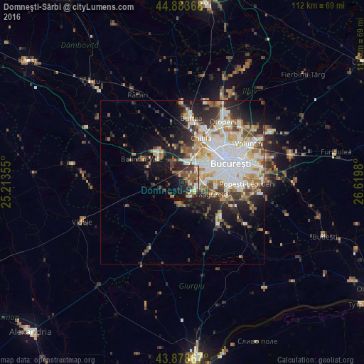
Analysis of Domneşti-Sârbi night lights 2016
Square area 10x10 km:
 2.38%
2.38%90-99
4.6%80-89
5.24%70-79
3.81%60-69
4.6%50-59
11.27%40-49
8.1%30-39
6.03%20-29
11.27%10-19
22.06%0-9
20.63%Square area 50x50 km:
6.54%90-99
5.71%80-89
2.39%70-79
2.63%60-69
2.79%50-59
2.71%40-49
3.35%30-39
2.83%20-29
5.31%10-19
8.33%0-9
57.43%Clear (daylight) street map image can be seen on geolist.org.
Map coordinates:
44° 53' 1.2" North, 25° 12' 48.8" East
44° 22' 60" North, 25° 55' 0" East
43° 52' 43.2" North, 26° 37' 11.3" East
Some cities around Domneşti-Sârbi sort by population:
• Sector 6
9.8 km =6.1 mi,  53°
53°
• Sector 5
12.3 km =7.6 mi,  87°
87°
• Măgurele
10 km =6.2 mi,  111°
111°
• Bragadiru
5 km =3.1 mi, 105°
• Chiajna
9.6 km =6 mi,  27°
27°
• Mihăileşti
6.3 km =3.9 mi,  186°
186°
• Bolintin Deal
11.3 km =7 mi,  318°
318°
• Cornetu
5 km =3.1 mi,  157°
157°
679112 (p: 6,393)
Sources (retrieved 2019-11-25):
» Earth at Night: Flat Maps 2012, 2016