Tărtăşeşti night lights from space
Night Light of Tărtăşeşti (Dâmboviţa) from space (Romania) Src. Average luminocity for 10x10km area is 2.1576% and for 50x50km: 17.7948%.
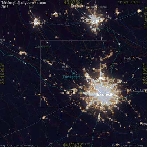
Analysis of Tărtăşeşti night lights 2016
Square area 10x10 km:
 0%
0%90-99
0%80-89
0%70-79
0%60-69
0.3%50-59
0%40-49
0.76%30-39
1.67%20-29
0.91%10-19
0.91%0-9
95.45%Square area 50x50 km:
4.64%90-99
3.9%80-89
1.59%70-79
1.75%60-69
2.11%50-59
1.96%40-49
2.43%30-39
2.45%20-29
3.55%10-19
6%0-9
69.62%Clear (daylight) street map image can be seen on geolist.org.
Map coordinates:
45° 4' 33.2" North, 25° 6' 34.8" East
44° 34' 38" North, 25° 48' 46" East
44° 4' 27.2" North, 26° 30' 57.3" East
Some cities around Tărtăşeşti sort by population:
• Buftea
10.9 km =6.8 mi,  99°
99°
• Joiţa
9.8 km =6.1 mi,  160°
160°
• Ulmi
10.4 km =6.5 mi,  194°
194°
• Răcari
8.9 km =5.5 mi,  314°
314°
• Crevedia
9.9 km =6.2 mi,  75°
75°
• Bolintin Deal
13.1 km =8.1 mi,  177°
177°
• Lunguleţu
13.6 km =8.5 mi,  288°
288°
• Ciocăneşti
3.9 km =2.4 mi,  49°
49°
665479 (p: 5,066)
Sources (retrieved 2019-11-25):
» Earth at Night: Flat Maps 2012, 2016