Domnești night lights from space
Night Light of Domnești (Ilfov) from space (Romania) Src. Average luminocity for 10x10km area is 40.3651% and for 50x50km: 25.2343%.
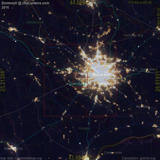
Analysis of Domnești night lights 2016
Square area 10x10 km:
 5.56%
5.56%90-99
7.62%80-89
4.6%70-79
2.06%60-69
3.33%50-59
11.59%40-49
10.32%30-39
6.35%20-29
12.22%10-19
20.32%0-9
16.03%Square area 50x50 km:
6.55%90-99
5.72%80-89
2.39%70-79
2.72%60-69
2.93%50-59
2.71%40-49
3.41%30-39
2.91%20-29
5.45%10-19
8.77%0-9
56.46%Clear (daylight) street map image can be seen on geolist.org.
Map coordinates:
44° 53' 57.8" North, 25° 12' 47" East
44° 23' 57.1" North, 25° 54' 58.2" East
43° 53' 40.8" North, 26° 37' 9.5" East
Some cities around Domnești sort by population:
• Sector 6
8.9 km =5.5 mi,  62°
62°
• Măgurele
10.8 km =6.7 mi,  120°
120°
• Joiţa
11.7 km =7.3 mi,  334°
334°
• Bragadiru
5.8 km =3.6 mi, 122°
• Chiajna
8.1 km =5 mi,  33°
33°
• Mihăileşti
8.1 km =5 mi,  184°
184°
• Bolintin Deal
10.1 km =6.3 mi,  311°
311°
• Cornetu
6.7 km =4.2 mi,  162°
162°
679119 (p: 5,423)
Sources (retrieved 2019-11-25):
» Earth at Night: Flat Maps 2012, 2016