Hohenau night lights from space
Night Light of Hohenau (Itapúa) from space (Paraguay) Src. Average luminocity for 10x10km area is 27.9742% and for 50x50km: 5.0849%.
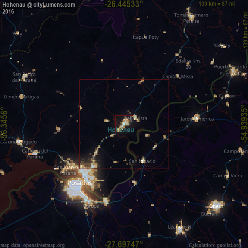
Analysis of Hohenau night lights 2016
Square area 10x10 km:
 1.59%
1.59%90-99
2.58%80-89
4.56%70-79
6.94%60-69
6.15%50-59
2.38%40-49
1.59%30-39
4.37%20-29
1.59%10-19
39.68%0-9
28.57%Square area 50x50 km:
0.25%90-99
0.39%80-89
1.06%70-79
0.8%60-69
0.99%50-59
0.33%40-49
0.86%30-39
1.07%20-29
0.89%10-19
3.4%0-9
89.97%Clear (daylight) street map image can be seen on geolist.org.
Map coordinates:
26° 26' 43.2" South, 56° 20' 44.2" West
27° 4' 23.3" South, 55° 38' 32.9" West
27° 41' 50.9" South, 54° 56' 21.7" West
Some cities around Hohenau sort by population:
• Posadas, AR
41.2 km =25.6 mi,  217°
217°
• Encarnación
36.2 km =22.5 mi, 217°
• Garupá, AR
49 km =30.4 mi,  202°
202°
• Jardín América, AR
41.3 km =25.7 mi,  85°
85°
• Candelaria, AR
44.1 km =27.4 mi,  193°
193°
• Obligado
4.5 km =2.8 mi,  11°
11°
• Gobernador Roca, AR
21.7 km =13.5 mi,  125°
125°
• Santo Pipó, AR
24.4 km =15.2 mi,  108°
108°
3437997 (p: 5,306)
Sources (retrieved 2019-11-25):
» Earth at Night: Flat Maps 2012, 2016