Santo Pipó night lights from space
Night Light of Santo Pipó (Misiones) from space (Argentina) Src. Average luminocity for 10x10km area is 3.4223% and for 50x50km: 3.0719%.
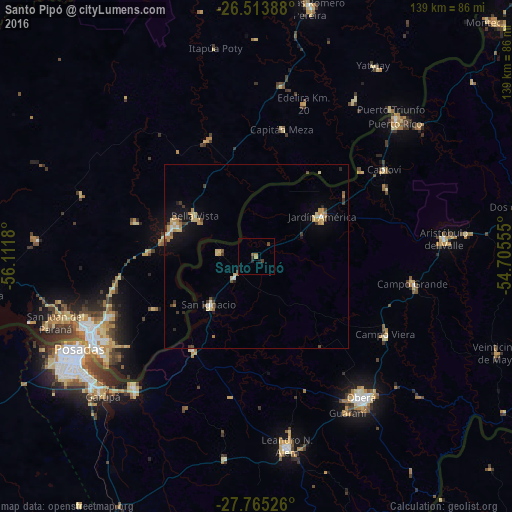
Analysis of Santo Pipó night lights 2016
Square area 10x10 km:
 0%
0%90-99
0%80-89
0%70-79
0.76%60-69
0.95%50-59
0.76%40-49
1.14%30-39
1.14%20-29
1.14%10-19
0.76%0-9
93.37%Square area 50x50 km:
0.15%90-99
0.24%80-89
0.72%70-79
0.53%60-69
0.51%50-59
0.18%40-49
0.4%30-39
0.6%20-29
0.27%10-19
1.62%0-9
94.76%Clear (daylight) street map image can be seen on geolist.org.
Map coordinates:
26° 30' 50" South, 56° 6' 42.5" West
27° 8' 28.8" South, 55° 24' 31.2" West
27° 45' 54.9" South, 54° 42' 20" West
Some cities around Santo Pipó sort by population:
• Oberá
47.9 km =29.8 mi,  143°
143°
• Jardín América
21 km =13 mi,  58°
58°
• Campo Grande
43.1 km =26.8 mi,  99°
99°
• Campo Viera
40.8 km =25.4 mi,  121°
121°
• Obligado, PY
25.3 km =15.7 mi,  298°
298°
• Gobernador Roca
7.4 km =4.6 mi,  227°
227°
• Capioví
41.7 km =25.9 mi, 55°
• Hohenau, PY
24.4 km =15.2 mi,  288°
288°
3428079 (p: 5,447)
Sources (retrieved 2019-11-25):
» Earth at Night: Flat Maps 2012, 2016